 Santa was sitting at a high-level strategic infrastructure planning table in an administrative office near the northern frontier, holding a glossy international logistics brochure.
He was aggressively circling map routes along the border corridor with a blue marker, tapping his desk authoritatively.
“Oye Banta, look at the speed of infrastructure across the border!” Santa said, adjusting his spectacles.
“China has built high-speed railways, multi-lane expressways, and hundreds of kilometers of straight transport tunnelsacross the Tibetan frontier in record time!”
“They have conquered the high altitude with massive civil works!”
“We share the exact same mountain border, so why are our Himalayan highway and rail projects moving with so much caution, environmental delay, and endless geological study?”
“We must match them kilometer for kilometer and tunnel for tunnel!”
“Speed is our only strategic priority!”
“Chalta hai!”
Banta set down a 3D topographic relief model of the entire Himalayan-Tibetan orogen, a spatial watershed drainage cross-section, and a comparative geomorphological hazard chart.
He tapped Santa’s map with a blunt pencil.
“Santa-ji, geopolitical borders exist on political paper, but geology carries zero passports!” Banta warned sternly.
“You are falling for the Plateau Fallacy!”
Santa scoffed, waving his brochure.
“Oye Banta!”
“What fallacy?”
“The coordinates are right next to each other on the border map!”
“High altitude is high altitude!”
“High altitude is not high relief, Santa!” Banta shouted, pointing to the dramatic slope variations on the 3D model.
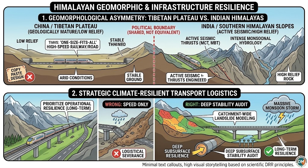
“Look at the fundamental, radical difference in geomorphology: across the border, the Tibetan Plateau sits as a massive, low-relief, relatively flat elevated plain at 4,500 meters, shielded from the Indian monsoon by the great mountain crests!”
“Their streams are gentle, their valleys are wide and shallow, and their bedrock is cold, permafrost-stabilized plateauterrain with minimal dynamic slope cutting!”
“But look at our side of the border: we are situated on the deeply incised, hyper-dissected, and tectonically compressed southern flank of the Himalayas!“
Santa leaned closer to the 3D model, his eyes tracing the sheer vertical drop of the southern valleys.
“On our side, Santa, the altitude drops from eight thousand meters to three hundred meters within a horizontal distance of barely one hundred kilometers!” Banta explained.
“Our mountains possess the highest relative relief on Earth!”
“We are directly in the crosshairs of the violent Indian summer monsoon, where atmospheric cloudbursts dump millions of tons of water down sheer vertical gorges drained by mighty, aggressive river systems like the Ganga, Indus, and Teesta!”
“When you blast into these vertical, deeply incised southern slopes to widen roads or drill low-level railway tunnels, you are cutting directly across active thrust faults and destabilizing ancient, fragile colluvial slopes that have no counter-support!”
“Slicing through our razor-sharp gorges is ten times more hazardous than excavating across a flat Tibetan plain!”
“If our strategic defence planners ignore this brutal physical asymmetry, the next monsoonal surge or seismic tremor will wash out our entire transport alignment, cutting off our border supplies instead of protecting them!”
“True sovereign defence lies in building geotechnically resilient, climate-smart infrastructure—not blindly copying plateau engineering on vertical mountain cliffs!”
Santa stared at the sharp, vertical ridges of the southern slopes on the model, realizing that sharing a border did not mean sharing a geology.
He quietly set down his blue marker.
“Oye Banta… so they are building on the flat roof of the house… but we are hanging on the crumbling outer balcony?”
“Precisely, Santa-ji,” Banta smiled.
“Respect the slope.”
“Build with geotechnical wisdom, so our lifeline routes stand firm when the nation needs them most!”
संता – बंता की इस जुगलबन्दी से आज हमने क्या सीखा:-
- हिमालयी और तिब्बती भू-आकृति में अंतर / The Geomorphological Asymmetry of the Himalayan Arc:
- केवल सीमा रेखा साझा करने से भू-विज्ञान नहीं बदलता। तिब्बत का पठार एक समतल, कम ढलान वाला और शुष्क इलाका है जहाँ निर्माण करना आसान है, जबकि भारतीय हिमालय की दक्षिणी ढलानों में दुनिया की सबसे तीव्र और गहरी घाटियाँ स्थित हैं। यहाँ मूसलाधार मानसूनी बारिश होती है और यहाँ सक्रिय भूकंपीय दरारें भी हैं। तिब्बत की तर्ज पर अंधी नकल करके यहाँ सड़कें और सुरंगे बनाना सीधे विनाश को आमंत्रण देना है / Sharing political boundaries does not imply geological equivalence. The Tibetan Plateau is an elevated, low-relief plateau with gentle gradients and arid conditions, whereas the southern slopes of the Indian Himalayas feature the highest relative relief on Earth, active seismic thrusts, and intense monsoonal hydrology. Linear infrastructure projects cannot copy plateau designs; they must be engineered specifically for highly dissected, high-relief terrain.
- सामरिक दृष्टि से सुरक्षित परिवहन नियोजन / Strategic Climate-Resilient Transport Logistics:
- सीमावर्ती क्षेत्रों में सड़कों और रेल मार्गों का निर्माण केवल ‘तेज गति’ देखकर नहीं, बल्कि दीर्घकालिक स्थिरता के आधार पर होना चाहिये। प्राकृतिक आपदाओं के समय सामरिक मार्ग बंद न हों, इसके लिये पूरे नदी बेसिन के भू-स्खलन और जल-प्रवाह का वैज्ञानिक ऑडिट अनिवार्य है / National security infrastructure along high-relief frontier corridors must prioritize long-term operational resilience over raw construction speed. Transport alignments must integrate catchment-wide landslide modeling, flood-stage clearances, and deep subsurface stability audits to prevent strategic logistical severance during extreme weather events.
संता – बंता की यह जुगलबन्दी आपको कैसी लगी, कृपया हमें जरुर बताये
व
इस जुगलबन्दी को बेहतर बनाने के लिये अपने सुझाव अवश्य दें।
हमें हमेशा की तरह आप के सुझावों, प्रतिक्रियाओं व कटाक्षो का बेसब्री से इंतजार रहता हैं और सच मानिये इसी के आधार पर हम अपने आप में, अपनी सोच व रचनात्मकता में सुधार करने को प्रेरित होते हैं।
सो अच्छा – बुरा जैसा आपको महसूस हुवा हो, कमेंट जरुर करते रहें।
#PlateauFallacy #HimalayanGeomorphology#BorderInfrastructure #StrategicResilience #TerrainAsymmetry #SantaBantaDRR
Leave a Reply