 Santa was sitting in his veranda in Shimla, surrounded by glossy, colorful maps printed on high-end paper.
He was holding a high-tech magnifying glass, tracing a finger along a bright green zone labeled “Stable Bedrock—Low Risk Zone.”
“Oye Banta!”
“Look at this marvel of modern science!” Santa cheered, waving a map.
“The scientists have used satellites, Remote Sensing, and GIS to map our whole ridge.”
“Besides other parameters they looked at the geology, the structures, and the topography.”
“See this green part where my ancestral cottage stands?”
“It says ‘In Situ Quartzite Bedrock.'”
“It’s as solid as an iron vault!”
“We are officially safe from the monsoon!”
Banta walked over, carrying two empty wooden crates.
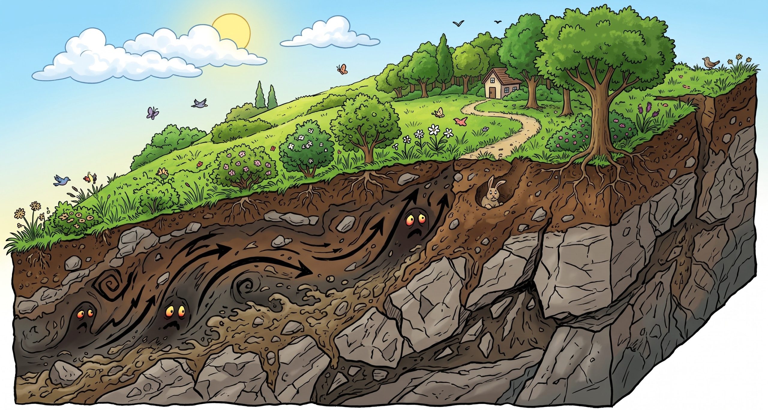
He set them down, walked to the edge of Santa’s lawn, and kicked his boot into the soft, grassy slope just below the veranda.
The grass easily peeled back, revealing a thick, loose, crumbly pile of broken rocks, sand, and powdery soil that went down as deep as the eye could see.
“Santa-ji,” Banta sighed, wiping his dusty hands.
“Your satellite map is a masterpiece of bones, but it’s completely blind to the flesh.”
“The map is telling you that the skeleton of the mountain is strong, but it’s completely missing the ten-meter-thick blanket of loose, disintegrated junk sitting right on top of it!”
“Junk?”
“Banta, this is lush green grass!”
“Look at the pretty bushes growing on it!” Santa protested.
“That is exactly the illusion, Santa,” Banta explained.
“Over centuries, wind, water, and winter frost actions break down the solid rock.”
“This fragmented mass accumulates on the slope and stabilizes just by hitting its Angle of Repose.”
“Then, pioneering weeds and grass grow over it, giving it the look of a solid, permanent hill.”
“But it’s not a solid hill; it’s a loose pile of rubble wearing a green coat!”
“Because geologists are trained to map the in situ solid rock beneath, and because measuring the depth of this loose overburden is incredibly difficult, our state-of-the-art hazard maps completely ignore it.”
“When the cloudburst hits, the satellite map won’t slide—but this invisible blanket definitely will!”
Santa looked from the green zone on the map to the crumbly rubble under his lawn.
“So… the satellite is mapping the floor, but my house is sitting on an unanchored carpet?”
“Precisely, Santa-ji,” Banta nodded.
“And if someone pulls that carpet, the strength of the floor won’t save your furniture!”
संता – बंता की इस जुगलबन्दी से आज हमने क्या सीखा:-
-
- हरी-भरी वनस्पतियां ढलान पर जमा गहरे, बिना जुड़े मलबे (unconsolidated debris) को छिपा सकती हैं। अतः किसी हरी ढलान को ठोस और सुरक्षित चट्टान समझने की भूल कभी भी न करें / Vegetation cover can mask deep accumulations of unconsolidated, fragmented debris resting at the angle of repose. Do not mistake a green slope for a structurally stable bedrock slope.
- मलबे की गहराई का मानचित्रण / Debris Depth in Hazard Mapping:
- पारंपरिक भूस्खलन जोखिम मानचित्र प्रायः इसलिए विफल होते हैं क्योंकि वे सतह पर मौजूद ढीले मलबे के विस्तार व गहराई को संज्ञान में नहीं लेते हैं। वास्तविक जोखिम के आंकलन के लिए मलबे के विस्तार व गहराई के आंकड़ों को शामिल करना अनिवार्य है / Traditional landslide hazard maps often fail because they omit the extent and depth of loose slope overburden. Risk models must integrate sub-surface debris depth to simulate real-world hazards.
संता – बंता की यह जुगलबन्दी आपको कैसी लगी, कृपया हमें जरुर बताये
व
इस जुगलबन्दी को बेहतर बनाने के लिये अपने सुझाव अवश्य दें।
हमें हमेशा की तरह आपके सुझावों, प्रतिक्रियाओं व कटाक्षो का बेसब्री से इंतजार रहता हैं औरसच मानिये इसी के आधार पर हम अपने आप में, अपनी सोच व रचनात्मकता में सुधार करने कोप्रेरित होते हैं।
सो अच्छा – बुरा जैसा आपको महसूस हुवा हो, कमेंट जरुर करते रहें।
#LandslideMapping #GISBlindSpot #HimalayanFragility #AngleOfRepose #DisasterScience #SantaBantaStories
Leave a Reply