
2021 Uttarakhand flood took everyone by surprise.
Flood requires huge amount of water within a short time span. The flash flood of February 7, 2021 in Dhauliganga valley of Uttarakhand Himalaya that killed 204 persons, and devastated two hydropower projects of 13.2, and 520 MW capacity however took place during the winter season when the discharge of glacier fed Himalayan rivers is minimum.
This incidence was at the same time not accompanied by a major rainfall event.
In such a situation pinpointing the source of the floodwaters was a major challenge.
Scientific Explanations of 2021 Uttarakhand Flood
Unlike common man, scientific community explores opportunities in such incidences to apply their analytical and reasoning skills, and come up with some new, and exciting insights.
Uttarakhand being studded with a number of premier scientific, and academic institutions, researchers working in these quickly studied this event using various tools, and tried their level best to explain the phenomenon causing this flood.
First to put forth an explanation for this event was however not from these institutions.
Dave Peltey, based on the analysis of the Planet Lab satellite imageries on February 7, 2021 itself, reported a rock mass together with some ice having been detached along a crack on the flank of Nanda Ghunti (5600 m), and fallen to 3800 m.
This, according to him, initiated a rock, and ice avalanche which travelled down the glacier generating vast quantity of dust, which was smeared to the west of the valley.
Energy generated by the impact of the free fall of huge rock mass, and ice over almost 1800 m was held responsible for quickly melting the snow and ice available in the area, and initiating a debris flow that rushed downslope to cause the devastation.
On February 9, 2021 Uttarakhand Space Application Centre (USAC), based on the analysis of LISS-IV satellite data, reported a lake having come into existence along the course of Rishiganaga river at a distance of around 6 km upstream of Rini due to mass movement along Raunthi Gadhera and expressed possibility of flood in the downstream areas due to the breach of this lake.
On February 10, 2021 Indian Institute of Remote Sensing (IIRS) based on the analysis of satellite imageries asserted that the avalanche triggering the event involved sudden movement, and melting of fresh snow over almost 14 sq km area.
In addition to the impact of the massive rock fall, this report attributed the presence of huge quantity of water to abnormal rise in temperature ascertained from the WRF model. Volume of water generated in this process was estimated to be 2-3 million cu m.
In another report based on the analysis of Sentinel-2 satellite imageries IIRS assessed 39.67 million cu m of overhanging rock mass as having dislodged on February 7, 2021 along a pre-existing crack on the flank of the western peak adjacent to Trishul glacier. This rock mass reportedly impacted the valley floor 1456 m below, near the snout of Trishul glacier generating 1.51 X 10¹²J energy that is assessed to have melted 4.5 million ton ice to produce around 4.53 million cu m water in 1.5 hours. This melt water according to the report resulted in flood, and devastation in the downstream areas.
On February 10, 2021 Wadia Institute of Himalayan Geology (WIHG), based on aerial reconnaissance, and field investigations reported that a rock avalanche has taken place on the valley walls of Raunthi Bank glacier below its snout from an elevation of 5600 m. According to this report the rock mass and debris so generated blocked the Raunthi Gadhera at an elevation of 3600 m for a few hours in the morning hours of February 7, 2021 and breach of this impoundment caused the flash flood, and ensuing devastation in the downstream areas. The report added that the debris flow back flooded a tributary of Raunthi Gadhera creating another impoundment.
Shrestha and others as also Glacier and Permafrost Hazards in Mountains (GAPHAZ), based on the analysis of satellite imageries identified an ice or rock/ice avalanche having taken place in the same area between September 19 and 26, 2016. Besides frictional melting, and liquification of ice, these reports suggested possibility of buried ice together with water trapped under, and within the 2016 avalanche debris getting reactivated by the present event, and contributing to the floodwaters.
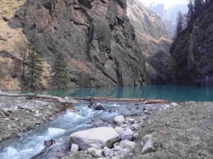
Photographs taken by the reconnaissance team on February 11, 2021 confirmed the presence of a debris dammed lake in the catchment of Rishiganga river. This was a cause of serious concern for the state as the breach of this lake could jeopardise safety, and security of the personnel engaged in rescue works at the hydropower project site at Tapoban. Efforts were therefore made to ascertain the dimensions of the lake, and assess the magnitude of threat posed by it. The lake however breached naturally on February 12, 2021.
Issues With the Explanation of the Scientists
- Rishiganga river, with a catchment area of 664 sq km, is the main tributary of Dhauliganga river, and it was blocked by debris brought down by the rock fall-avalanche along Raunthi Gadhera on February 7, 2013. Rishiganga river was thus not involved in the flash flood incidence which resulted in additional discharge of 1629 cumecs in Alaknanda river.
- The discharge of all other streams remaining the same, entire additional discharge was thus contributed by Raunthi Gadhera alone.
- It is hard to believe if Raunthi Gadhera with catchment area of only 83 sq km could contribute 4.53 million cu m water without interplay of some other factor.
- To match the volume of water estimated by IIRS the catchment of Raunthi Gadhera with surface area of 83 sq km has to witness a cloudburst event (100 mm rain in 1 hour), and almost 60% of the precipitation has to contribute to surface flow (60% of 8.3 million cu m = 4.98 million cu m).
- There however was no rain in the area on the day of the flash flood.
- As assessed from IIRS report, 4.5 million ton of ice has to melt to generate around 4.53 million cu m water that is required for causing this flood event. All the reports agree that the rock mass which is estimated as being 39.67 million cu m by IIRS, got detached from a higher elevation with some ice mass.
- No report however logically explains the source of ice in this large quantity; 4.5 million ton.
- Reports suggest that the rock mass got dislodged from a higher elevation in the catchment of Raunthi Gadhera, and fell vertically down on the valley floor some 1.5 – 1.8 km below.
- Vertical cliff of almost 2.0 km is however not observed anywhere around the affected area.
- IIRS report suggests the impact of the dislodged rock mass on the valley floor 1456 m below, to have generated 1.51 X 10¹²J energy resulting in the melting of ice. However for initiating a flash flood, melting has to be instantaneous and accordingly IIRS report asserts it to have taken place in 1.5 hours.
- Calculations however establish that melting of 4.5 million ton of ice is to take significantly longer time.
2021 Uttarakhand Flood Reinvestigated
Not convinced with the explanations put forth by various scientists efforts were put in to assess flood vulnerability of the affected area. Historical record of floods in the region was thus collected from various sources, and field investigations were also carried out. The historical data so collected clearly establishes particularly high flood vulnerability of Dhauliganga valley that witnessed major floods including landslide lake outburst floods (LLOF) previously in 1957, July 20, 1970, and 2002.
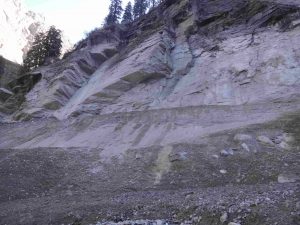
Evidences of previous damming were observed on the right bank of Raunthi Gadhera upstream of its confluence with Rishiganga river. These lacustrine deposits consist of an inter-bedded sequence of sand and pebbles. Evidences of damming were also observed on the left bank of Dhauliganga river on road section close to hot water spring at Tapoban.
Sharp rise in the temperature on the very day of this incidence was also observed; between February 6 and 7, 2021 Tapoban at an altitude of 2000 m experienced rise of 2.8o and 5.4o C respectively in minimum and maximum temperature while the rise at Auli (2600 m) was observed to be 6.0o and 9.6o C respectively.
Scenario Reconstruction
On the basis of the field evidences sequential damming at four different places in the catchment of Dhauliganga river and subsequent dam breach at three places is put forth as being responsible for this flash flood incidence.
Damming of Raunthi Gadhera
There was blockade in the upper catchment of Raunthi Gadhera by the rock, and ice mass detached from a higher elevation together with the morainic deposits mobilized by the impact from the valley floor. Residents of the surrounding villages reportedly heard sound of falling rocks around 0200 hrs on February 7, 2021. This is taken as the timing of the rock fall, and creation of the rock fall-avalanche barrier along the course of Raunthi Gadhera at an altitude of around 3600 m.
Moreover huge volume of debris comprising of a mixture of ice blocks, rock fragments, and morainic material was observed along the course of Raunthi Gadhera. This material could not have moved downslope without the intervention of appreciable volume of water. There was thus impoundment of water in the upper reaches of Raunthi Gadhera.
The region had witnessed precipitation on February 4 and 5, 2021 and fresh snow was present in the upper reaches of the catchment on February 6, 2021. Sharp rise in temperature on the very day of this incidence facilitated melting of freshly accumulated snow as also detached ice mass. The water so generated got accumulated upstream of the barrier created by the landslide/avalanche debris. As put forth by other reports, buried ice and water trapped under and within the 2016 avalanche debris would have also added to this water.
Lake on Rishiganga River
Build up of hydrostatic pressure caused failure of the barrier in the upper reaches of Raunthi Gadhera around 1015 hrs on February 7, 2021 resulting in sudden downslope gush of water. Large volume of glacial material, ice, and rock mass was carried downstream in this incidence. This movement generated a plume of dust that was observed to be smeared on the valley walls as also over vegetation. Large rounded chunks of ice were also observed along the valley slope which refute the hypothesis of instant melting of ice resulting in flash flood.
The fast moving, and debris, ice, and rock mass laden flow of Raunthi Gadhera smashed against the valley wall on the right bank of Rishiganga river (2315 m). High angular relationship of the two streams caused flow deflection facilitating back flow along Rishiganga river. Large volume of rock, and debris material was thus transported upstream along Rishiganga river for about 500 m, and dumped there. This barrier was observed to be around 50 m high and 100 m wide. Presence of embedded ice blocks was also observed in this barrier.
Upstream of this barrier a lake was created on Rishiganga river along a deep gorge carved in very hard quartzitic rocks showing three sets of consistent joints. This barrier cut off the discharge of Rishiganga river, and the water draining down from Raunthi Gadhera alone flowed downstream along the course of Rishiganga river till February 12, 2021.
Intermittent Damming N of Murunna
Despite Rishiganga river being blocked the floodwaters of Raunthi Gadhera travelled downstream along the course of Rishiganga river. Field evidences suggest that the course of Rishiganga river was blocked again intermittently to the north of Murunna. Constricted valley configuration at this site facilitated the damming. Deposits of debris were also observed at this site on both the banks, and evidences on the valley walls suggest the impoundment to be upto 40-50 m above the riverbed.
The discharge of Rishiganga river cut off, but for this impoundment the flood would not have been particularly devastating. This damming ensured accumulation of huge quantity of water, and with the breach of this barrier floodwaters rushed downstream washing away the Rishiganga hydropower project upstream of Rini.
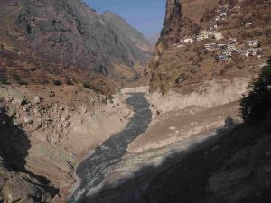
Intermittent Damming around Rini
Rishiganga river meets Dhauliganga river at almost right angles near Rini village at an altitude of 1960 m. The floodwaters of Raunthi Gadhera travelling down the course of Rishiganga river along with huge amount of debris, and rock mass hit the valley wall on the right bank of Dhauliganga river deflecting its flow, and causing deposition of debris and back flow along the course of Dhauliganga river for a short duration.
The evidences of impoundment of water were observed on the valley walls along the course of Dhauliganga river upto 1 km upstream of its confluence with Rishiganga river, with impoundment level assessed as being 3-4 m above the normal river level.
Though for a short duration, it is this blockade that ensured accumulation of huge volume of water, and its breach resulted in the devastation of the downstream areas including the hydropower project at Tapoban.
[…] Chamoli district of Uttarakhand is one of the most disaster prone district of Uttarakhand and apart from 1999 Chamoli Earthquake the district has witnessed landslides and flash floods in 1893, 1894 and 1970 besides recent flooding of Alaknanda, Pindar and other rivers in 2013 and Dhauliganga – Rishiganga floods in 2021. […]