 Santa was sitting comfortably in an administrative office in the northern plains of Bihar, India, hundreds of kilometers away from the high snow-capped Tibetan plateau.
He was reviewing a flood protection wall file while sipping sweet lassi, glancing casually at the peaceful, slow-moving river running through the agricultural plains outside his window.
Banta rushed into the room, holding an active transboundary telemetry dashboard from the International Centre for Integrated Mountain Development (ICIMOD) and a satellite flood propagation map.
He slammed the desk with his hand.
“Santa-ji!”
“Sound the district flood sirens, order the river embankment gates closed, and alert the disaster response teams along the riverbanks immediately!” Banta shouted.
“The transboundary flash-flood wave that initiated yesterday morning in Tibet and tore through Nepal’s Trishuli, Lhende Khola, and Bhote Koshi rivers is crossing the international border and entering our plains right now!”
Santa laughed heartily, offering Banta a glass of lassi.
“Oye Banta!”
“Have you been struck by heatstroke?”
“Look out the window!”
“We are in the flat, sunny plains of India, surrounded by sugarcane and paddy fields!”
“The international border is secured with checkpoints, customs officers, and barbed wire fences!”
“Tibet is hundreds of kilometers away across high mountain ranges, and Nepal is a completely different sovereign country!”
“How can a rockfall in high-altitude foreign territory touch my peaceful plains district?”
“Water respects international borders and administrative boundaries!”
“Chalta hai!”
Banta shook his head in absolute disbelief, pulling Santa out of his chair and dragging him to the riverfront monitoring pillar, where the automated water-level gauge was already climbing by three feet every ten minutes, carrying splinteredpine trunks and Himalayan shale dust.
“Santa-ji, geopolitical treaties and border check-posts exist in human law, but gravity and hydrology carry zero passports!” Banta shouted.
“You are falling for the Border Boundary Fallacy!”
Santa blinked, watching a massive uprooted mountain pine log sweep past in the muddy current.
“Oye Banta… that tree didn’t grow in our plains!’
“That’s a high-altitude Himalayan pine!”
“Exactly, Santa!”
“It grew thousands of meters up in the glaciated valleys!” Banta said.
“The catastrophic event that struck on the morning of 26 August 2026 originated in the remote Tibetan Himalayas.”
“The falling mountain pulverized ice into water, entrained sediment through Nepal’s Trishuli, Tadi, and Bhote Koshi catchments, obliterated bridges and road corridors, and kept its terrifying momentum for hundreds of kilometers down-gradient straight into the Indian plains!”
“Look at our historical precedents: the October 2023 South Lhonak lake outburst in Sikkim destroyed the Chungthang dam and devastated downstream towns for over a hundred kilometers, while the 2000 Yigong disaster in Tibet surged straight into Arunachal Pradesh, washing away major bridges!”
“In the Himalayas, every river is a transboundary conveyor belt!’
“What happens at the roof of the world becomes a humanitarian emergency in the living room of the plains hours later!”
“If we don’t establish real-time, automated transboundary data-sharing protocols, satellite telemetry links, and joint early warning sirens between China, Nepal, and India, our downstream flood warnings will always arrive after the water has already washed away our bridges!”
Santa stared at the churning, grey, sediment-laden floodwaters rapidly creeping up the concrete embankment pillar, his administrative complacency washing away.
He grabbed his emergency radio transmitter.
“Oye Banta… so an avalanche in the clouds isn’t a local foreign news story… it’s an incoming missile headed straight for our plains?”
“Precisely, Santa-ji,” Banta smiled.
“The Himalayas are one single, interconnected ecological house.’
“When the roof falls, the ground floor shakes.’
“Let’s issue the warning!”
संता – बंता की इस जुगलबन्दी से आज हमने क्या सीखा:-
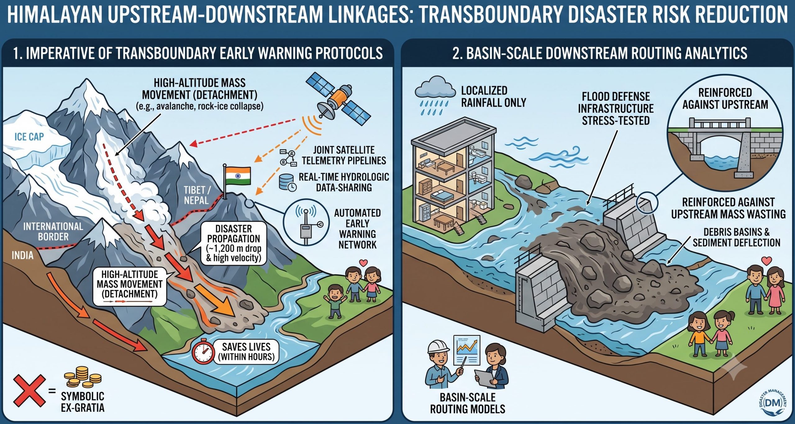
- सीमा-पार पूर्व चेतावनी और डेटा साझाकरण की अनिवार्यता / The Imperative of Transboundary Early WarningProtocols:
- हिमालयी आपदाये किसी देश की सीमा या पासपोर्ट की मोहताज नहीं है। तिब्बत या नेपाल के पहाड़ों में टूटने वाला ग्लेशियर या चट्टान कुछ ही घंटों में भारत के मैदानी इलाकों में तबाही मचा सकती है। इसलिए भारत, नेपाल और अन्य पड़ोसी देशों के बीच रियल-टाइम सैटेलाइट डेटा और नदी जलस्तर की स्वचालित पूर्व चेतावनी प्रणालियों (transboundary data-sharing) का होना जीवन रक्षक है / High-altitude cryospheric mass movements operate on watershed geographies that completely transcend geopolitical boundaries. A disaster initiating in Tibet or Nepal can propagate into the Indian plains within hours. Regional Disaster Risk Reduction requires automated, real-time hydrologic data-sharing, joint satellitetelemetrypipelines, and unified transboundary early warning networks.
- बेसिन–स्तरीय बाढ़ मार्ग मॉडलिंग / Basin-Scale Downstream Routing Analytics:
- मैदानी इलाकों में बाढ़ नियंत्रण केवल स्थानीय बारिश के आधार पर नहीं किया जा सकता है। अतः सैकड़ों किलोमीटर दूर ऊंचे पहाड़ी क्षेत्रो में होने वाले विशाल हिम-स्खलन और मलबे के बहाव के आधार पर पूरे नदी बेसिन का हाइड्रोलॉजिकल मॉडल तैयार किया जाना चाहिये / Downstream civil defense planning in the plains must not evaluate flood hazards solely against localized rainfall. Flood defense infrastructure must be stress-tested against upstream, high-velocity mass-wasting and hyper-concentrated slurry runouts originating hundreds of kilometers away.
संता – बंता की यह जुगलबन्दी आपको कैसी लगी, कृपया हमें जरुर बताये
व
इस जुगलबन्दी को बेहतर बनाने के लिये अपने सुझाव अवश्य दें।
हमें हमेशा की तरह आप के सुझावों, प्रतिक्रियाओं व कटाक्षो का बेसब्री से इंतजार रहता हैं और सच मानिये इसी के आधार पर हम अपने आप में, अपनी सोच व रचनात्मकता में सुधार करने को प्रेरित होते हैं।
सो अच्छा – बुरा जैसा आपको महसूस हुवा हो, कमेंट जरुर करते रहें।
#TransboundaryDRR #NepalFloods2026 #CascadingHazards #ICIMOD#HimalayanWatersheds #SantaBantaStories
Leave a Reply