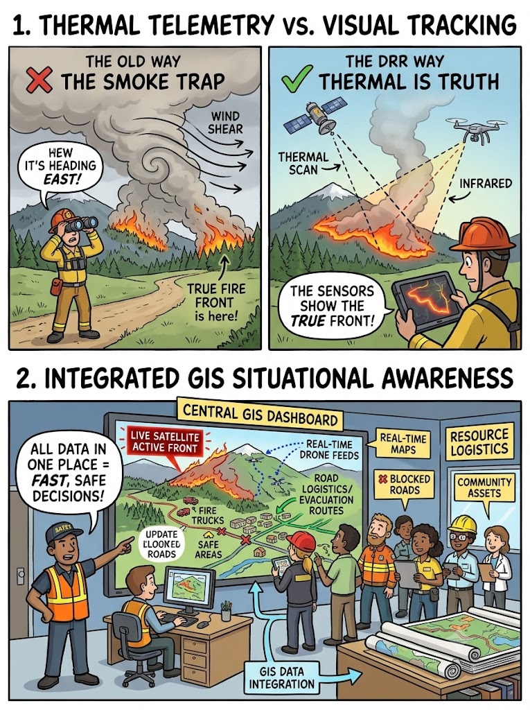
 Santa was working as an emergency field response coordinator during a major summer wildfire event moving through a heavily forested mountain valley corridor.
He was standing near a dirt track, surrounded by a fleet of manual water tankers, screaming orders through a megaphone based on where he could see grey smoke blowing through the treetops.
Banta arrived at the mobile operations vehicle, deploying a tactical thermal-infrared imaging drone while monitoring a live satellite feed from an ESA thermal anomaly sensor dashboard on a wide monitor panel.
“Oye, Banta!”
“Bring those water trucks down this southern dirt road!” Santa yelled, wiping charcoal ash off his forehead.
“The smoke looks incredibly thick over that ridge!”
“The fire must be moving directly toward our village outpost.”
“Hurry!”
Banta grabbed Santa by his high-visibility vest and pulled him into the command vehicle, pointing a finger at a bright, pulsing neon-red hotspot signature flashing on the satellite map five kilometers away in the completely opposite direction.
“Santa-ji, turn off your megaphone and look at the invisible truth!” Banta said sternly.
“You are tracking the smoke column, but you are completely blind to the actual heart of the inferno!”
“The smoke is blowing south due to upper-level wind shear, but the real fire boundary is aggressively breaking north toward our critical medical clinic asset!”
Santa blinked, staring at the satellite thermal signatures.
“Oye Banta!”
“The sky looks clear to the north!”
“How can a fire be burning where there is no visible black smoke column?”
“Because multi-temporal thermal sensors and drone diagnostics read heat wavelengths, not look at smoke, Santa!” Banta shouted.
“In major global emergencies like the multi-billion dollar wildfire cycles in California or remote mountain forest basins, relying on manual visual reports creates fatal operational gaps.”
“Satellites identify thermal anomalies instantly through the canopy, while our tactical drones execute close-range ground-truth damage assessments.”
“This integrated GIS situational awareness platform combines real-time wind models with fuel load metrics to generate a predictive containment scenario.”
“If you dispatch our water resources based on where the smoke looks scary, the actual fire will cut off our evacuation paths from behind!”
“True disaster response means utilizing earth observation platforms to guide our search-and-rescue teams with spatial precision rather than running after drifting clouds of ash!”
Santa watched the drone feed confirm the northern flare-up, the spatial data saving his deployment from a fatal entrapment.
He instantly redirected his water trucks.
“Oye… so the thermal camera looks right through the green leaves to catch the spark before it eats the whole valley?”
“Exactly, Santa-ji,” Banta smiled.
“When the terrain is on fire, geospatial intelligence is the only compass that keeps you from burning your options.”
संता – बंता की इस जुगलबन्दी से आज हमने क्या सीखा:-
- विज़ुअल ट्रैकिंग बनाम थर्मल रिमोट सेंसिंग / Thermal Telemetry Over Visual Tracking:
- वनों में लगने वाली आग (wildfires) के दौरान केवल धुएं को देखकर राहत दलों को भेजना खतरनाक होसकता है, क्योंकि हवा के कारण धुआं दूसरी दिशा में जा सकता है। इसके लिए सैटेलाइट के ‘थर्मलइन्फ्रारेड सेंसर’ (thermal sensors) और ड्रोन विजुअल्स का उपयोग कर आग के असली केंद्र (hotspots) की पहचान की जानी चाहिए / Visual observation of smoke plumes during wildfire crises induces significant directional errors due to localized wind shear. Emergency response must prioritize multi-temporal satellite thermal infrared sensors and drone telemetry to isolate true active front lines and hotspot vectors.
- एकीकृत जीआईएस (GIS) स्थितिजन्य जागरूकता / Integrated GIS Situational Awareness:
- तीव्र गति से फैलने वाली आपदाओं के समय राहत और बचाव कार्यों के सटीक संचालन के लिएरियल-टाइम रिमोट सेंसिंग डेटा को स्थानीय सड़कों और महत्वपूर्ण संपत्तियों के मानचित्रों के साथ एककेंद्रीकृत जीआईएस (GIS) डैशबोर्ड पर एकीकृत किया जाना चाहिए / Maximizing resource deployment efficiency during rapid-onset disasters mandates combining real-time remote sensing inputs with local road logistics and asset maps inside a centralized GIS situational awareness dashboard.
संता – बंता की यह जुगलबन्दी आपको कैसी लगी, कृपया हमें जरुर बताये
व
इस जुगलबन्दी को बेहतर बनाने के लिये अपने सुझाव अवश्य दें।
हमें हमेशा की तरह आपके सुझावों, प्रतिक्रियाओं व कटाक्षो का बेसब्री से इंतजार रहता हैं औरसच मानिये इसी के आधार पर हम अपने आप में, अपनी सोच व रचनात्मकता में सुधार करने कोप्रेरित होते हैं।
सो अच्छा – बुरा जैसा आपको महसूस हुवा हो, कमेंट जरुर करते रहें।
#ThermalInfrared #WildfireResponse #SituationalAwareness #DroneDamageAssessment#GeospatialIntelligence #SantaBantaStories
Leave a Reply