
Just imagine that the early settlers in the Himalayan region were aware of the intricacies of Hydrological Cycle, groundwater presence, means of enhancing groundwater recharge, and had even mastered the art of groundwater exploration.
Hope this is no testing time for the limits of your imagination.
What if I say that by the end of this article you would be convinced that whatever you heard in the previous paragraph is real, and not a wild imagination.
But for that you have to be patient, and follow me to the very end.
Water scarcity despite ample rains
In case you have gone through the previous article on this issue, you would have realised that atmospheric precipitation is the only source of water in the Himalayas, and despite receiving appreciable rains owed mostly to SW monsoon, mountainous areas face scarcity of water due to the constraints posed by topography.
You would have also gathered that the early settlers in the region initially utilized the water of spring fed streams, as the water of glacier fed rivers was not fit for drinking; both during summer, and rainy seasons. With the passage of time through observation, analysis, experimentation, and accumulation knowledge of generations these people mastered the art of developing seepages into dhara, so as to conveniently utilize this water. These people at the same time invoked various religio-magical rituals around these water sources to ensure their cleanliness, and maintenance.
The summer ordeal
Atmospheric precipitation resulting in surface, and subsurface flow, storage, and discharge ensure year round availability of water , and sustain life in the mountains.
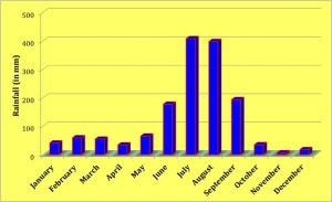
Review of the precipitation pattern however reveals that overwhelmingly large proportion is received during the monsoon period (mid-June to min-September). Except for a few spells of winter rains that are generally fuelled by western disturbances the Himalayas experience prolonged dry spell after the monsoonal rains.
Weak monsoon, as also failed, or depleted winter rains thus have an adverse impact on the discharge of the streams, as also yield of the dharas, particularly during summers when many of these tend to dry out. This is commonplace when there is less of winter precipitation followed by long drawn hot, and dry spells during summers.
Ensuring sustained, and ample availability of water has always been a major concern for the people, and dependence upon dharas, and streams alone amounted to jeopardising the survival which no community could afford. Situation thus warranted exploration of alternatives. and this was exactly what these people did.
Inquisitiveness of the people
Depleted winter rains followed by long drawn dry spell during the summer season resulted in reduced productivity, and even complete drying of various water sources.
This inflicted hardships, and misery upon the community; major portion of productive time, and energy being wasted in searching productive sources, and arranging water. And it was not water alone; shortage of water resulted in scarcity of fodder that also had to be arranged for household cattle. All this resulted in neglect of routine household, and farm pursuits resulting in reduced farm productivity, and undernourishment. In the long run this amounted to jeopardising the survival of the community.
People were therefore forced to pay particular attention towards various aspects related to availability of water, maximising availability, conserving available water, and exploring this important resource in different ways.
This enquiry, and application of mind for solving this important problem raised many questions related to sudden appearance of water at some places along the hill slope, and fluctuation in its availability with changing season.
- What is the source of the water oozing along the hill slope?
- Where was this water before appearing at that place?
- Why is the discharge not same throughout the year?
- What causes seasonal variability in discharge?
- Why does this water sometimes dry up completely?
- Why does the dried seepage again becomes productive after the rains?
- How can these sources be prevented from drying up?
Groundwater presence
Based upon observation, experience, and accumulated knowledge it was not difficult for these people to deduce early that the water flows from higher to lower elevation.
Drying of water sources, particularly during the summer season, and their rejuvenation after the onset of rains was the preliminary clue provided by nature that the water oozing along the hill slope was actually rainwater. Based on routine, and long drawn obervation the temporal relationship between rains, and rejuvenation of dried water sources these people confirmed this assertion.
Using the rule pertaining to the flow of water these people then deduced that the water appearing along the hill slope was rainwater, and it was coming from the higher elevation.
By this deductive learning these people started to unlock the intricacies of Hydrological Cycle; the water seeping out of the hill slope was the same water that had infiltrated under the ground surface at higher elevations. Higher elevations, because water flows from higher to lower elevation.
The water that infiltrating the ground surface at higher elevations was however not observed on the hill slope before it oozed out. This led these people to deduce that the water going below the surface at higher elevations travelled through a path deep below the surface to appear on the hill slope below. This provided these people an important clue on the presence of water below the surface; groundwater.
This led to the evolution of the understanding of underground reserves that stored rainwater, and slowly released it in the form of seepages along the hill slope.
Water – forest linkage
Even today masses in the Himalayan region believe that areas in the proximity of oak (banj) forest have productive sources of water, and it is often asserted that the roots of the banj trees conserve water. This observed difference in the distribution, and differential yield of the seepages around slopes with banj, and pine (chir) forest in their vicinity led these people to investigate reasons thereof.
Aware of the fact that water flows from higher to lower elevation these people would certainly have concentrated their attention on the higher reaches of the slopes that had seepages.
High vegetation density, luxurious undergrowth, and presence of a thick layer of decomposing litter are characteristic of a banj forest, and these differentiate it from chir forest that is literally bereft of undergrowth. This difference would not have been hard to notice for these inquisitive, and observant people.
This difference was subsequently correlated with percolation of rainwater beneath the ground, and hence high water yield of the springs around oak forests.
In fact the forest often referred to as banj forest is a mixed multistoried forest of oak-rhododendron (burans)-bay berry (kafal), with luxurious undergrowth of bushes, and shrubs. This forest as the same time has thick layer of foliage, or decomposing litter that acts like a spongy surface that facilitates prolonged moisture retention at higher elevations, and thus promotes groundwater recharge, which is responsible for high water yield of the springs in the downslope areas.
Based on these observations these people understood that the availability of water was dependent upon the quantity of water joining the groundwater reserves from the higher reaches of the hill. These people could at the same time correlate the quantity of water joining the groundwater reserves with the duration for which water remained at higher elevations. Longer the presence, better the chances of water joining the subsurface reserves.
Based on their keen observation of nature, and armed with the knowledge so derived these people devised various measures for maximising recharge of groundwater.
Sacred groves
After understanding the relationship between healthy forest cover in the upper reaches of the hill, and the water joining the subsurface reserves, these people devised ways of protecting, and promoting vegetal cover on the upper reaches of the hills.
The forest in the upper reaches of the hills were thus customarily dedicated to the local deities. In order to assert, and remind this sacred association temples of the local deities were constructed on the upper reaches of the hills. This helped in regulating, or restricting the exploitation of these forests. It is therefore no wonder that apart from those along the rivers, particularly at the confluence, most temples in the mountains are located at the top of the hills; Surkanda Devi in Tehri Garhwal, Purnagiri in Champawat, Bijli Mahadeo in Kullu and the like.
In some places exploitation of these forests was totally banned while in others, the same was regulated through a set of rules. At some places extraction of resources from these forests was resorted to after a predefined time interval, while at others the forest was split into sectors with provision of extraction of resources from each sector in rotation.
Fulfilment of certain rites, and rituals together with offering oblations to the deity was a commonly ensured before initiating extraction of resources from these forests. This often required arranging feast for the entire community, which ensured that the sacred forest left aside. It was also a measure to ensure food security.
In many instances the local inhabitants were allowed to collect the required forest produce. However, the use of lopping, and cutting tools, and implements was banned in these forests. This restriction ensured limited, and required extraction of the forest produce from these forests.
Some resources including mythological bramha kamal (Saussurea obvallata) required for various traditional rites, and rituals grow in the areas dedicated to the local deities. It is important to note that the local inhabitants still do not pluck these by hand. There is a tradition of plucking these by mouth while kneeling down on ground. By doing so the local inhabitants potray this as an act of some innocent animal unaware of rules of the sacred forest, and consequences of violating these. Being an innocent animal the deity could not punish it. On the one hand this severely limits the extraction of resources from the forest, while on the other it ensures compliance of the custamary restrictions.
Relationship between lopping, and forest health is presently well understood. It has been scientifically established that annual, heavy and indiscriminate lopping precludes flowering, and seed production for regeneration. Loss of photosynthetic surface as a consequence of repeated lopping is scientifically held responsible for early senescence, and impaired ability to coppice.
A comparative study has shown that trees lopped every year as also at the interval of two years do not produce seeds, while trees lopped at the interval of three years or more do produce seeds.
Recharge pits
These people were however not satisfied with the amount of water naturally percolating to the subsurface reserves, and wanted to augment this volume so as to minimise uncertainnty in water availability.
Based on the accumulated knowledge of generations these people knew that infiltration of water is a function of the duration for which rainwater stays on the surface. These people thus concentrated their attention on devising ways of retaining the precipitated water at higher elevations for longer durations. This was however not a condition which could be fulfilled easily as the topography, and laws of gravitation did not favour its fulfilment, and most water ran downslope soon after the rains.
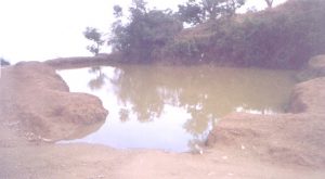
This however could not derail the quest of these people who soon came up with a solution. They started to dig pits in the upper reaches to retain the rainwater for a longer duration. With experience they found that the ones dug over relatively gentle ground in the proximity of slope break naturally facilitated collection of surface flow in adequate quantities, and were effective for augmenting groundwater recharge.
They called these structures chals and khals that were ditches dug out along the valley slope profile at places having break in slope; places where surface slope was relatively gentle and rainwater from the upper slopes naturally ran down towards these.
Settlement of clay layer at the bottom of these pits over the passage of time ensured that these retained water for appreciable duration after the rains. Besides augmenting recharge of ground water these catered to the needs of the grazing animals.
[…] of Common Property Rights: In the Himalayas, the loss of a community forest or a traditional water source (Dhara / naula) is rarely featured in a compensation package. Yet, its loss forces women to trek […]