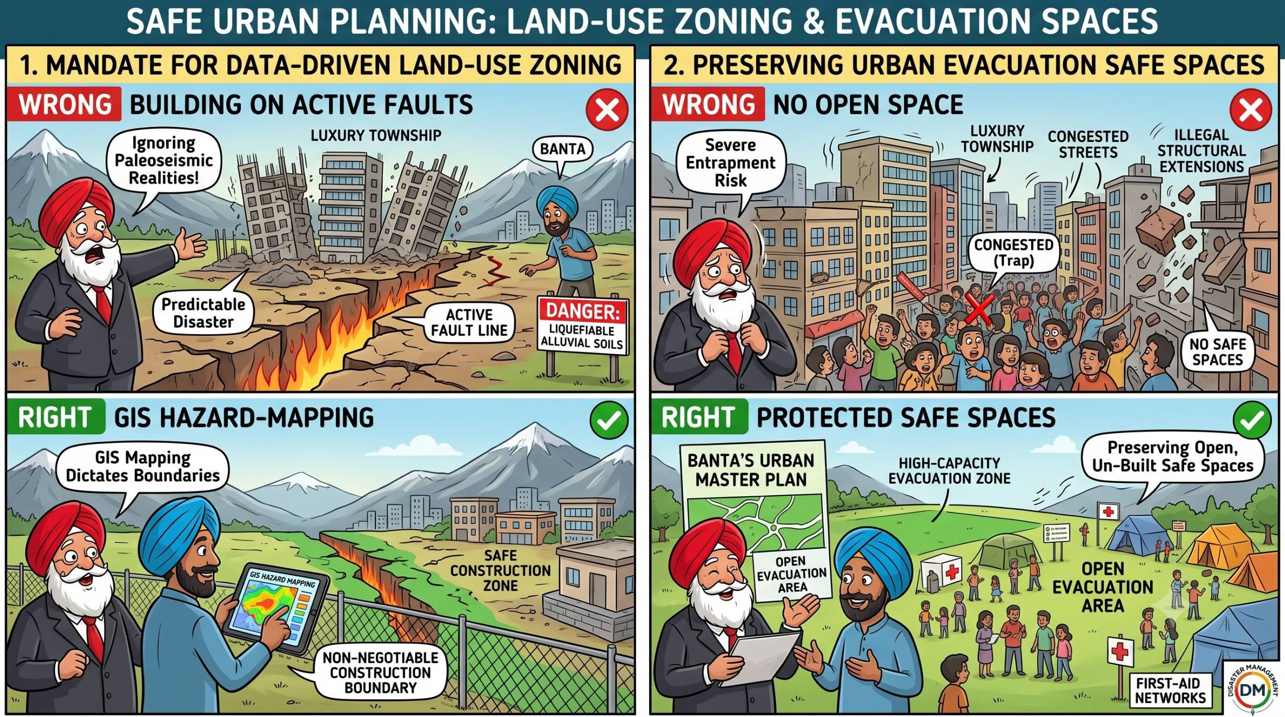
 Santa was standing on a flat, premium patch of terrace land right near a steep mountain slope incline, holding a gold-embossed brochure for a new, high-density residential township project he was planning to fund.
The location had a gorgeous valley layout and was priced cheap due to its proximity to an active geological shear zone.
“Banta, look at this real estate goldmine!” Santa smiled, pointing to his survey stakes.
“The mountain view is pristine, the soil is flat, and I can build forty high-rise luxury villas right along this line!”
“Why do these government planners keep insisting on complex clearances?”
“This land is perfectly ready for modern lifestyle development!”
Banta stepped onto the plot, carrying a high-resolution GIS hazard zonation map generated via paleoseismic and satellite data.
He pointed his tablet screen directly at Santa’s survey boundary; the screen showed Santa’s exact coordinates sitting squarely inside a blood-red shaded stripe labelled CRITICAL HAZARD ZONE: ACTIVE FAULT LINE RUPTURE EXTENSION & LIQUEFACTION SLOPE.
“Santa-ji, you aren’t laying out a luxury villa township; you are drawing chalk lines for a structural funeral!” Banta said seriously, holding up the map.
“You are completely ignoring high-resolution hazard maps and land-use risk planning!”
Santa scoffed, kicking a survey stake into the dirt.
“Oye Banta!”
“These computer maps are just theoretical paintings made by office scientists using old rocks and paleoseismology data!”
“The ground under this grass hasn’t moved in a hundred years.”
“Why should a red stripe on a screen block my commercial business expansion?”
“The ground hasn’t moved because it’s accumulating an enormous slip deficit, you stubborn developer!” Banta shouted, pointing to the steep, unstable slope directly above them.
“Paleoseismic data shows that this exact segment is mature for a major thrust event.”
“When that locked energy releases, the fault line will rip through this exact coordinate like a giant pair of scissors!”
“By using GIS and remote sensing to create high-resolution hazard maps, science isn’t trying to slow down your business—it’s trying to map our survival!”
“True risk reduction mandates that we enforce strict land-use planning in our urban master plans—restricting high-density developments on active fault traces, liquefiable soils, or steep landslide-prone slopes, and mandating open safe spaces for public evacuation!”
“If you ignore the geomorphological boundaries of the valley today, the earth will tear your entire township footprint in half tomorrow!”
Santa looked from the flashing red fault corridor on Banta’s tablet to the deep, silent mountain cleft running right along his plot boundary, the historical reality of tectonic slip deficits clearing his greed.
He quietly pulled up his survey stakes.
“Oye… so the map isn’t an administrative hurdle… it’s just showing me the mountain’s actual cleavage lines?”
“Precisely, Santa-ji,” Banta said.
“Build on the stable, certified zones that engineering science approves, and leave the fault lines to breathe in peace.”
संता – बंता की इस जुगलबन्दी से आज हमने क्या सीखा:-
- भू–उपयोग और जोखिम मानचित्रण / The Mandate for Data-Driven Land-Use Zoning:
- सक्रिय फॉल्ट लाइनों (active fault lines) या खिसकने वाली पहाड़ी ढलानों पर बहुमंजिला इमारतों कानिर्माण करना भू-वैज्ञानिक सत्यों की अनदेखी करना है। हाई-रिज़ॉल्यूशन जीआईएस (GIS) मैपिंग केआधार पर इन संवेदनशील क्षेत्रों में निर्माण पर पूर्ण कानूनी प्रतिबंध होना चाहिये / Constructing high-density residential or commercial assets directly over active fault lines or liquefiable alluvial soils ignores paleoseismic realities, transforming predictable geomorphic movements into man-made disasters. GIS hazard mapping must dictate non-negotiable construction boundaries.
- शहरी मास्टर प्लान में खुले सुरक्षित स्थानों का संरक्षण / Preserving Urban Evacuation Safe Spaces:
- भूकंपीय रूप से सक्रिय क्षेत्रों के शहरी मास्टर प्लानों में खुले, निर्माण-मुक्त पार्कों और मैदानों का संरक्षणअनिवार्य होना चाहिये, ताकि आपदा के समय लोग इन सुरक्षित स्थानों का उपयोग निकास और राहतशिविरों के लिये कर सकें / Urban master plans across seismically active terrains must mandate the preservation of open, un-built safe spaces to function as high-capacity evacuation zones during high-intensity seismic events.
संता – बंता की यह जुगलबन्दी आपको कैसी लगी, कृपया हमें जरुर बताये
व
इस जुगलबन्दी को बेहतर बनाने के लिये अपने सुझाव अवश्य दें।
हमें हमेशा की तरह आपके सुझावों, प्रतिक्रियाओं व कटाक्षो का बेसब्री से इंतजार रहता हैं औरसच मानिये इसी के आधार पर हम अपने आप में, अपनी सोच व रचनात्मकता में सुधार करने कोप्रेरित होते हैं।
सो अच्छा – बुरा जैसा आपको महसूस हुवा हो, कमेंट जरुर करते रहें।
#LandUsePlanning#GISHazardMapping #Paleoseismology #ActiveFaultLines #UrbanZoningLaws #SantaBantaStories
Leave a Reply