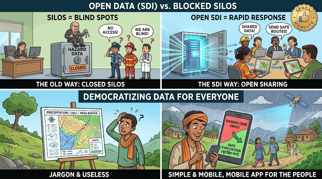
 Santa was working as a district administrative officer, sitting behind a high counter in his office.
He had just received an official directive to upload all the district’s newly generated high-resolution land-use maps, digital elevation files, and drone hazard paths into an online Open Spatial Data Infrastructure (SDI) portal for free public and inter-agency access.
“Banta, this is an administrative security breach!” Santa grumbled, locking his hard drive inside a metal drawer.
“We spent months collecting this valuable geographic data!”
“Why should I upload our premium GIS maps onto an open online portal where any common citizen, local NGO, or competing department can download it for free?”
“Data is administrative power!”
“I will keep this drive under lock and key!”
Banta walked into the office, accompanied by a local community volunteer holding a basic smartphone running a simplified, open-source mobile GIS app translated into the local vernacular language.
“Santa-ji, unlock that drawer and plug in your drive immediately!” Banta said, tapping the desk.
“Your data hoarding isn’t protecting administrative power; your data hoarding is creating an informational blackout that traps our most vulnerable communities during a crisis!”
Santa crossed his arms, looking defensive.
“Oye Banta!”
“It’s professional data!”
“Common citizens don’t have the capacity or training to read advanced geospatial layers.”
“Why create administrative confusion?”
“They don’t need a PhD in remote sensing to read a simple safety line on a mobile app, Santa!” Banta countered, pointing to the volunteer’s phone screen.
“Look at this open-source app.”
“When you upload our district hazard maps into an Open Spatial Data Infrastructure (SDI), the system automatically translates those complex digital layers into easy, accessible visual indicators.”
“A marginalized family living in an informal settlement block can open this app, see exactly whether their home sits inside a high-risk flood zone pathway, locate the nearest open emergency shelter, and view the safest evacuation route designated by our office!”
“Programs aligned with the Sendai Framework for DRR prove that data accessibility is a fundamental pillar of climate adaptation equity!”
“If you keep this spatial data locked inside your secret metal drawer, our first responders won’t have situational awareness, our local communities won’t know when to evacuate, and your administrative power will just be a ledger of preventable casualties!”
“True public governance means turning data silos into open spatial shields that protect every citizen equally!”
Santa looked at the simple, clear safety route displayed on the volunteer’s phone, the democratic power of open data clearing his administrative possessiveness.
He pulled out the hard drive and plugged it back into the network.
“Oye Banta… so an open portal means my maps travel straight into a family’s hand to save them before the storm?”
“Precisely, Santa-ji,” Banta smiled, initiating the public upload.
“When data is shared transparently, the entire community stands together on solid ground.”
संता – बंता की इस जुगलबन्दी से आज हमने क्या सीखा:-
- ओपन स्पेशल डेटा इन्फ्रास्ट्रक्चर (SDI) की आवश्यकता / The Mandate for Open Spatial Data Infrastructures (SDIs):
- महत्वपूर्ण सुरक्षा और आपदा मानचित्रों (hazard data) को सरकारी फाइलों या गुप्त ड्राइव्स में बंद रखना एकप्रशासनिक विफलता है। आपदा के समय तुरंत कदम उठाने के लिए ‘ओपन स्पेशल डेटा इन्फ्रास्ट्रक्चर‘ (SDI) के माध्यम से इस डेटा को सभी विभागों या व्यक्तियों के लिये उपलब्ध करवाया जाना चाहिये / Locking critical hazard datasets inside departmental silos creates institutional blind spots. Implementing Open Spatial Data Infrastructures (SDIs) is a mandatory Sendai Framework requirement to ensure real-time cross-agency data sharing and rapid response coordination.
- मोबाइल भौगोलिक सूचना प्रणाली (GIS) द्वारा सुरक्षा का लोकतंत्रीकरण / Democratizing DRR via Mobile GIS Applications:
- आपदा सुरक्षा तकनीक केवल विशेषज्ञों तक सीमित नहीं होनी चाहिये; जटिल सैटेलाइट डेटा को स्थानीयभाषाओं में सरल ‘मोबाइल भौगोलिक सूचना प्रणाली ऐप्स’ (mobile GIS apps) में बदलकर गरीब और पिछड़े समुदायोंतक पहुँचाया जाना चाहिये ताकि वे स्वयं अपनी सुरक्षा कर सकें / Climate risk mitigation must be equitable. Translating complex remote sensing layers into accessible, vernacular mobile GIS applications empowers marginalized communities to identify localized hazard zones and independently execute evacuation protocols.
संता – बंता की यह जुगलबन्दी आपको कैसी लगी, कृपया हमें जरुर बताये
व
इस जुगलबन्दी को बेहतर बनाने के लिये अपने सुझाव अवश्य दें।
हमें हमेशा की तरह आपके सुझावों, प्रतिक्रियाओं व कटाक्षो का बेसब्री से इंतजार रहता हैं और सच मानिये इसी के आधार पर हम अपने आप में, अपनी सोच व रचनात्मकता में सुधार करने को प्रेरित होते हैं।
सो अच्छा–बुरा जैसा आपको महसूस हुवा हो, कमेंट जरुर करते रहें।
#SpatialDataInfrastructure #SendaiFrameworkEquity #MobileGISApps#DataDemocratization #ClimateAdaptation2026 #SantaBantaStories
Leave a Reply