 Santa was working as a regional development coordinator for low-income housing blocks, standing at his desk with a magnifying glass.
He was trying to identify which specific informal settlement sectors, tin-roof chawls, and crowded slums along the coastal drainage contours were most vulnerable to upcoming monsoonal storm surges.
“Look at my focus, Banta!” Santa proudly pointed his magnifying glass at a blurry satellite photograph printed on a standard piece of glossy paper.
“I am manually scanning these house roofs one-by-one to count the structures.”
“Give me six months, and I will have a complete structural vulnerability index for the entire district board!”
Banta walked into the room, holding a laptop running a specialized semantic segmentation computer vision pipeline based on a U-Net deep neural network architecture.
He loaded the digital satellite feed, and within exactly forty seconds, the screen highlighted thousands of high-risk tin-roof boundaries in a bright, shimmering neon green outline.
“Santa-ji, drop your magnifying glass before you strain your eyes into absolute bankruptcy!” Banta smiled, sliding the laptop over Santa’s printed paper.
“You are trying to count a megacity slum belt using a hand tool, while this neural network has classified the asset risk of the entire delta basin before your tea could even cool down!”
Santa adjusted his glasses, staring at the rapidly generated risk outlines.
“Oye Banta!”
“This looks like a video game layout!”
“How can a computer program look at a roof and calculate if a family inside is vulnerable to a flood?”
“It calculates by running automated semantic segmentation on high-resolution satellite arrays, Santa!” Banta explained.
“Look at this breakthrough framework used in India called Project Sunny Lives.”
“It deploys specialized U-Net deep neural networks directly onto satellite imagery.”
“The AI automatically categorizes structural roofing materials, evaluates local terrain elevation models, and calculates the exact socio-economic vulnerability of low-income settlements!”
“Globally, from 1980 to 2024, the US alone experienced 403 weather and climate disasters exceeding $1 billion each, with the annual average jumping to 23 events recently!”
“In developing context blocks, these disasters cause disproportionate human misery because informal housings lack structural engineering.”
“By utilizing Project Sunny Lives protocols, disaster management agencies can map and prioritize structural aid, target pre-disaster retrofitting cesses, and organize precision evacuations for the most marginalized sectors long before the storm surge hits the coastline!”
“It eliminates our equity gaps using intelligent machines!”
Santa watched the U-Net architecture calculate risk scores for forty thousand individual structures in real time.
He slowly packed away his magnifying glass.
“Oye… so the machine doesn’t just see the roofs from space, it sees the safety gap of the people living under them?”
“Precisely, Santa-ji,” Banta said.
“True risk reduction uses planetary intelligence to protect the households that need it the most.”
संता – बंता की इस जुगलबन्दी से आज हमने क्या सीखा:-
- यू–नेट (U-Net) न्यूरल नेटवर्क की भूमिका / Automated Semantic Segmentation via U-Net:
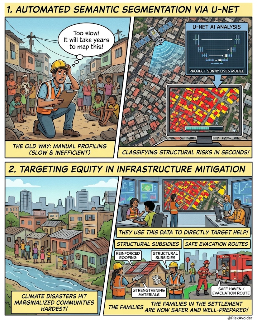
- घनी आबादी वाली मलिन बस्तियों (slums) में हाथ से घरों की संवेदनशीलता का आंकलन कर पाना असंभव है। इसके लिये हाई-रिज़ॉल्यूशन सैटेलाइट तस्वीरों पर ‘यू-नेट‘ (U-Net) न्यूरल नेटवर्क जैसी कंप्यूटर विज़न तकनीक का उपयोग करके प्रत्येक घर के जोखिम स्तर का स्वचालित वर्गीकरण किया जा सकता है / Manual structural vulnerability profiling is highly inefficient for high-density informal settlements. Deploying U-Net deep neural networks on high-resolution satellite imagery (Project Sunny Lives model) automates semantic segmentation, classifying structural risks across vast urban deltas in seconds.
- बुनियादी अवसंरचनात्मक न्यूनीकरण में समानता सुनिश्चित करना / Targeting Equity in Infrastructure Mitigation:
- जलवायु आपदाये सबसे गरीब और असुरक्षित बस्तियों को सबसे ज्यादा प्रभावित करती हैं। एआई (AI) आधारित जोखिम मानचित्रण लोक कल्याणकारी संस्थाओं को सटीक आंकड़े देता है ताकि आपदा से पहले ही सबसे कमजोर घरों तक सरकारी मदद और सुरक्षा राहत पहुंचायी जा सके / Climate disasters disproportionately impact marginalized populations in sub-standard housing. AI-driven risk mapping bridges equity gaps by providing public utilities with precision data to target pre-disaster structural subsidies and safety evacuation reserves.
संता – बंता की यह जुगलबन्दी आपको कैसी लगी, कृपया हमें जरुर बताये
व
इस जुगलबन्दी को बेहतर बनाने के लिये अपने सुझाव अवश्य दें।
हमें हमेशा की तरह आपके सुझावों, प्रतिक्रियाओं व कटाक्षो का बेसब्री से इंतजार रहता हैं औरसच मानिये इसी के आधार पर हम अपने आप में, अपनी सोच व रचनात्मकता में सुधार करने कोप्रेरित होते हैं।
सो अच्छा – बुरा जैसा आपको महसूस हुवा हो, कमेंट जरुर करते रहें।
#ProjectSunnyUNet #ComputerVisionDRR #SatelliteRemoteSensing #InformalSettlements#ClimateEquity #SantaBantaStories
Leave a Reply