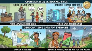
Unlocking the Hard Drive: Why Data Hoarding is a Disaster Strategy: Santa locks his district’s newly generated high-resolution flood maps inside a metal drawer, treating geospatial data as a private administrative asset. Banta and a local volunteer deploy an open-source mobile GIS app to prove how Open Spatial Data Infrastructures (SDIs) democratize climate safety, turning bureaucratic silos into lifesaving community shields.
Santa Banta
The Samosa Stand and the Billion-Dollar Weather Matrix
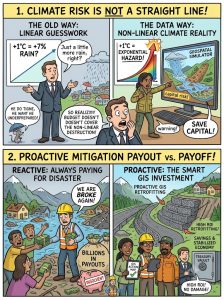
The Billions Matrix: Why Climate Intelligence is the Ultimate Financial Shield: Santa tries to cancel a geospatial risk simulator contract, believing that standard cash reserves can handle future weather disasters. Banta deploys an interactive GIS risk assessment widget to prove how a 1°C atmospheric spike triggers non-linear economic destruction, demonstrating why predictive data is mandatory for fiscal survival.
The Wildfire Smoke Shield and the Thermal Laser
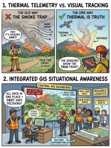
Chasing Smoke, Missing the Fire: How Satellite Thermal Sensors Outsmart Wildfires: Santa directs a fleet of emergency water tankers based on where the forest smoke column looks thickest. Banta intercepts the deployment using multi-temporal satellite thermal anomalies and tactical drone feeds, revealing how earth observation platforms see through smoke to track the hidden front lines of multi-billion dollar disasters.
The Recipe in the Soil and Santa’s Costly Shortcut
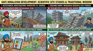
Treating geotechnical site investigations as optional overhead invites disaster in the geologically active Himalayas; safe development demands rigorous subsurface probing before laying a single stone. By integrating vernacular architectural wisdom and local, sustainable materials into modern building codes, mountain regions can simultaneously safeguard lives, celebrate cultural heritage, and unlock resilient eco-tourism economies.
The Sinking Megacity and the Digital Elevation Mirror
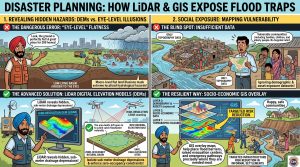
The Sinking Sink: How LiDAR Exposes the Deadly Trap of Flat Real Estate: Santa attempts to pack two hundred family homes into a low-lying urban basin, claiming the ground feels perfectly level under his feet. Banta deploys a high-resolution Digital Elevation Model (DEM) and GIS vulnerability layers to prove why human eyes cannot detect sub-meter flood basins, saving a community from an impending sub-surface disaster.
The Blindfold Blueprint and the 7% Cloudburst
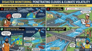
Looking Through the Storm: How Space Radar Defeats Midnight Cloudbursts: Santa attempts to monitor a massive midnight flood using a household flashlight and a paper map. Banta steps in with space-born Synthetic Aperture Radar (SAR) telemetry to show how cloud-penetrating satellite technology maps environmental disasters in real time, bypassing atmospheric barriers to save millions during extreme weather events.
Santa’s Secret Project and Banta’s Open Janam-Patri
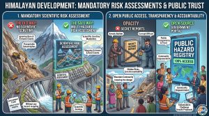
Major infrastructure development in the fragile Himalayas cannot afford to treat scientific scrutiny as an afterthought; making comprehensive, multi-hazard risk assessments mandatory for extreme events is vital to preventing preventable catastrophes. Placing these technical evaluations into open public access empowers mountain communities and stakeholders with the transparency needed to interrogate unsafe engineering and enforce genuine accountability.
The “Drop, Cover, Hold On” Drill and the Samosa Stampede
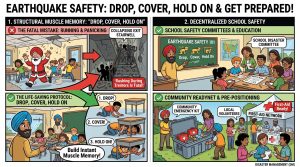
The Samosa Stampede: Why Running Out During an Earthquake is a Fatal Mistake: Santa cancels a mandatory school earthquake drill, claiming that running out fast is common sense. Banta uses a high-decibel reality check from the 2005 Kashmir tragedy to prove why rushing into stairwells during active tremors is fatal, and why building “Drop, Cover, Hold On” muscle memory is a non-negotiable school safety standard.
The Fault-Line Villa and the GIS Colour Sieve
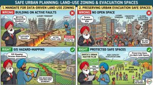
The Fault Line Fortune: Why Building on Active Earth Fractures is a Deadly Gamble: Santa attempts to fast-track a premium luxury housing township right over a cheap, active geological shear zone. Banta uses high-resolution GIS hazard mapping and paleoseismic tracking data to prove why ignoring land-use risk planning guarantees structural shear failure during the next major thrust event.
The Dashboard Alarm and the Two-Minute Warning
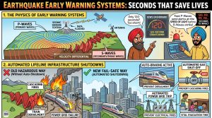
The 120-Second Reflex: How Automated Systems Freeze Cities Before the Quake: Santa mocks an advanced Earthquake Early Warning System dashboard, believing a two-minute countdown is too short to save anyone. Banta breaks down the engineering physics of seismic P-waves, showing how automated relays shut down power grids and isolate gas lines to save millions from cascading secondary hazards.