 The majestic Himalayas, a global biodiversity hotspot and the source of mighty rivers, are increasingly becoming synonymous with natural disasters. Instances of landslides and flash floods, along with the devastating losses these inflict, are undeniably on the rise.
While the pervasive influence of climate change certainly contributes significantly to the intensification and increasing frequency of these events, attributing every catastrophe solely to it would be an oversimplification.
A deeper, more nuanced understanding reveals a complex interplay of geological factors, changing land-use patterns, unsustainable development practices, and a gradual erosion of traditional wisdom.
Here we delve into the intricate dynamics of Himalayan landslides, exploring their underlying causes, the challenges in mitigation, and a comprehensive way forward towards building genuine resilience.
Landslide Dynamics : Beyond Simple Rockfall
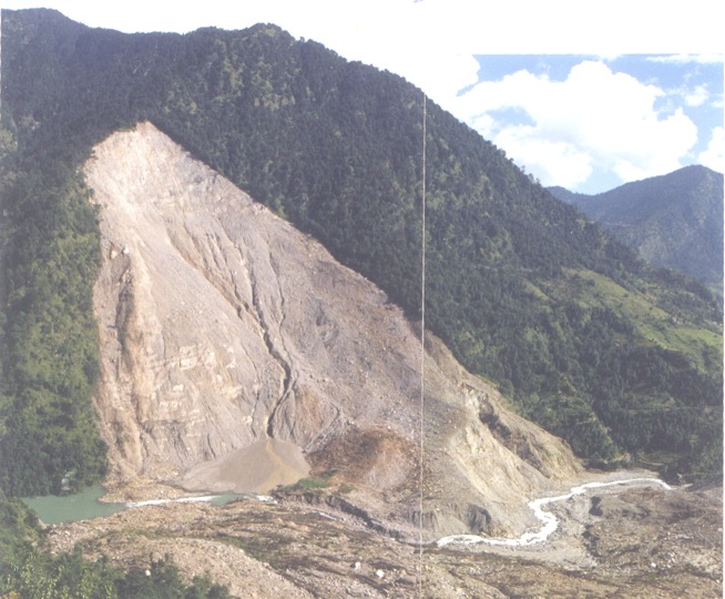
A landslide is fundamentally defined as the downslope movement of a mass of rock, debris, or earth.
However, contrary to popular perception, it doesn’t always involve the dramatic breaking or disintegration of the in situ bedrock.
In a significant number of cases, landslides are triggered by the movement of weathered rock mass and accumulated debris that has been slowly gathering on upper slopes over considerable periods. This unconsolidated material, often a legacy of past geological events or weathering processes, remains precariously perched until disturbed by a critical “trigger.”
These triggers are predominantly heavy rainfall and intense surface water flow, which saturate the ground, reduce friction, and increase the weight of the slope material. Occasionally, earthquake shaking can also act as a powerful catalyst, destabilizing already vulnerable slopes.
The understanding of this subtle, often slow, accumulation of weathered material is crucial to comprehending the inherent instability of many Himalayan slopes. Moreover, it needs to be understood that the rainfall howsoever intense and even cloudburst can’t very often break or disintegrate the in situ bedrock.
The Himalayan Paradox: Tradition vs. Modernity
For centuries, Himalayan communities, through their keen observation, experimentation and transmission of accumulated knowledge over generations, developed a profound, intuitive understanding of their environment, shaping their settlement patterns and agricultural practices to coexist with, rather than contend against, the formidable forces of nature.
Tradition of Prioritising Safety Over Comfort
Historically, the very presence of landslide debris was recognised as a natural process that facilitated aquifer recharge and soil development.
Most old habitations in the Himalayan region are thus, ironically, located in close proximity of old, naturally stabilised landslides. The wisdom of the ancestors however lies in their acute awareness of the inherent vulnerability of these unconsolidated deposits.
Consequently, they invariably sited their habitations at higher, more stable locations, often preferring safety and long-term security over immediate comfort or ease of access.
This traditional knowledge, passed down through generations, was a cornerstone of their resilience.
Economic Pressures and Road-Induced Relocation
The economic landscape of the mountains has undergone a significant transformation.
Mountain agriculture has become increasingly economically unviable, primarily due to the differential appreciation in the prices of coarse agricultural outputs compared to rising input costs, fast decreasing farming hands, increasing menace of wild animals and market access challenges.
This, coupled with a pervasive trend of outmigration from rural areas, has led to large tracts of agricultural land, particularly the meticulously maintained terraces in upslope regions, lying barren and neglected.
Concurrently, the rapid construction of roads along streams and rivers in the valleys has dramatically reshaped human settlement patterns.
The roads, while facilitating connectivity, have inadvertently concentrated economic activities and services in low-lying areas.
Furthermore, the ban on traditional building materials – local stone, slate, and timber, coupled with the increased cost of transporting modern materials – sand, cement, bricks, and iron bars, has made construction prohibitively expensive with increasing distance from road-heads.
This confluence of factors has effectively incentivised masses to relocate near the roads – areas that offer economic opportunities and ease of access, but are, critically, relatively more vulnerable to riverine hazards and slope instability.
Unintended Consequences of Development
While intended to foster progress, many recent developmental initiatives have inadvertently contributed to the problem.
The construction activities, often carried out without adequate geological assessment, proper waste management, or scientific risk assessment, have resulted in a significant added unconsolidated debris load on the hill slopes.
This anthropogenic debris, often dumped haphazardly, acts as a new source of instability, leading to increased instances of landslides and making already devastating debris flows more frequent and destructive.
Unpacking the Problem: Key Challenges in Landslide Management
Addressing the complex and rapidly escalating problem of landslides in the Himalayas requires a multi-faceted approach that acknowledges several critical challenges.
Nature’s Subtle Warnings: The Call for Awareness
Even though the final collapse of a slope can be swift and catastrophic, nature often provides subtle warnings of increasing distress.
These signs can manifest as ground tilting, localised subsidence, the appearance of ground fissures or cracks, and fluctuations in spring discharge (e.g., springs drying up or new ones appearing).
These critical indicators are best observed by the local communities, who live intimately with the land. However, for these observations to be effective, the masses must be made acutely aware of these warning signs.
This cannot be achieved through passive advertising alone; it demands active, continuous engagement and education at the grassroots level, building a cadre of informed citizen observers.
The Information Gap: Disseminating Hazard Assessments
It is not that landslide hazard, vulnerability, and risk assessments haven’t been undertaken. Such exercises have been conducted by the state government (USDMA) and agencies like the Geological Survey of India (GSI) for decades.
The critical flaw, however, lies in the dissemination of these results.
The findings are often not translated and communicated to the masses in plain, simple, easy-to-understand language, devoid of technical jargon. This is what happened with the ambitious Hazard, Risk and Vulnerability study undertaken with the World Bank support, Uttarakhand Disaster Recovery Program on the aftermath of 2013 disaster in Uttarakhand.
Crucially, these lack local context and illustrative examples relevant to the specific communities.
Consequently, the affected populations remain largely unaware of the precise risks looming over their habitations and livelihoods, and therefore, cannot be justly accused of ignorance or negligence.
Mapping the Unseen Threat: Unconsolidated Debris
As established, most landslides are caused by the downslope movement of unconsolidated material. It is therefore imperative that detailed mapping of this debris be undertaken across vulnerable slopes.
This mapping should not be a superficial exercise but a rigorous geological assessment to understand the volume, composition, and stability of these deposits. Based on this detailed mapping, the susceptibility of mass movement for specific areas can be accurately assessed, forming the bedrock of effective land-use planning.
The Debris Dilemma: Construction Waste and Slope Stability
The accelerated pace of various construction works across the Himalayan region – roads, hydropower and railway projects, buildings – has led to a manifold increase in debris production.
Alarmingly, there is a pervasive lack of a sound debris disposal policy or adequate disposal sites. As a result, a major portion of this construction debris is unscientifically dumped along the slopes.
While a large volume of this debris eventually rolls down into rivers and streams, significantly increasing siltation of reservoirs and causing riverbed aggradation – raising the riverbed level, a substantial volume remains precariously perched on the slopes.
It is this anthropogenic debris, often unstable and poorly compacted, that frequently initiates new landslides or exacerbates existing ones, thereby enhancing the devastating potential of both landslides and flash floods.
Road Construction: A Double-Edged Sword
Road construction and widening, while essential for connectivity, are major contributors to slope instability in the Himalayas and it is a combo observation that hitherto stable slopes become perpetually prone to instability.
Beyond producing huge volumes of debris, these activities have several detrimental impacts:
Enhanced Groundwater Infiltration
The creation of flat road surfaces often disrupts natural drainage patterns, leading to enhanced groundwater infiltration into the hill slope, increasing pore water pressure and reducing slope stability.
Disturbance of Angle of Repose
Cutting into the toe of a slope or dumping material on its face disturbs the natural angle of repose of the existing debris, making it inherently unstable.
Altering Geological Relationships
Road cuts often change the angular relationship of the bedding or foliation planes of the underlying rocks with respect to the hill slope.
This is particularly problematic where the rocks dip valley-ward, making certain slopes perpetually prone to landslides, as the rock layers are essentially sliding down their natural inclination.
The Subjective Nature of Instability Assessment
Slope instability is a complex phenomenon, a function of numerous interacting parameters – geology, hydrology, seismicity, land use, and the like.
Consequently, any agency or individual, no matter how competent, can only put forth the magnitude of instability probabilistically.
This inherent lack of absolute objectivity means that the assessment becomes open to interpretation, and unfortunately, can be utilized or dismissed according to convenience or political expediency, rather than being treated as a definitive scientific warning.
Ignoring Ancestral Wisdom: The Peril of Ground Subsidence
With an increasing craving for modern convenience and comfort, there’s a growing tendency to ignore traditional dictates of not settling over agricultural lands, especially in areas with deep, unconsolidated soil profiles.
This disregard for ancestral wisdom has led to a complicated problem of ground subsidence, particularly in areas like Joshimath. This subsidence is often related to the piping of fine soil particles from the unconsolidated ground below, exacerbated by faulty drainage and increased water infiltration, leading to the gradual collapse of the overlying structures.
Contextualizing Warnings: The Need for Local Relevance
For any warning to be effective, it must be clear, specific, and locally relevant.
The people receiving the warning must be able to decipher it in an intended manner, understanding its implications for their immediate surroundings.
Most importantly, communities must have a ready, actionable plan to implement immediately upon receipt of a warning.
This level of preparedness cannot be achieved overnight; it demands dedicated, continuous effort and deep engagement at the grassroots level. This ensures that masses are not only aware but also possess the capacity and a pre-defined plan to act upon warnings, alongside the knowledge to recognize nature’s early warning signs and promptly report them to authorities.
The Elusive Landslide Warning: Precision vs. Panic
For agencies like the Uttarakhand State Disaster Management Authority (USDMA) to issue effective public warnings, they require discrete information regarding space, time, and magnitude. Warnings issued without these precise elements can cause widespread panic and, conversely, repeated “missed alarms” can lead to public complacency and a casual attitude towards future warnings.
While landslides generally accompany heavy rains, water is only one of several contributing factors. Except for specific, actively monitored sites with instrumentation, it is incredibly challenging for any agency to issue a definitive, precise warning of a landslide‘s exact occurrence.
This inherent uncertainty in precise prediction poses a significant dilemma for warning systems.
The Silent Threat: Agriculture Terrace Induced Landslides (ATIL)
With increasing outmigration and a rapid decline in the area under active agriculture, many agricultural terraces, particularly those located further from habitations, are left barren and neglected.
Crucially, little to no attention is paid to the upkeep and maintenance of their breast walls (retaining walls).
During spells of heavy rainfall, the debris and soil resting behind these damaged or collapsed walls often become saturated, initiating mudflows that, over a short distance, can rapidly transform into massive, destructive landslides.
These ATILs represent a growing, often overlooked, source of instability.
The Element of Surprise: New Landslides and Casualties
Armed with generations of traditional knowledge, local communities generally understand the recurring nature of landslides in their vicinity and often maintain a safe distance from known unstable zones.
Consequently, a significant proportion of landslide-related casualties are associated with new, previously unrecorded landslides that emerge suddenly. These novel events often overwhelm the masses with surprise, as they fall outside the realm of their historical experience and traditional understanding of vulnerability.
Forging a Resilient Future: A Multi-pronged Way Forward
The solution to this complex and rapidly growing problem in the Himalayas lies in a holistic approach, characterized by close collaboration between local communities, research agencies, and concerned government departments.
Empowering Communities: The Power of Mass Awareness
It must be fundamentally understood that voluntary compliance with safety norms holds the key to achieving genuine disaster resilience. Mass awareness is the most effective tool to foster this compliance.
Communities need to be made acutely aware of the seriousness of landslide risks and other hazards in their specific region, and the potential losses these could cause.
This information must be conveyed in plain, simple words, avoiding technical jargon.
Crucially, previous incidents from the surrounding region, rather than abstract or distant examples, should be utilised to illustrate the dangers, alongside the accessible dissemination of results from past studies and surveys.
Building Capacity at the Grassroots
Beyond mere awareness, communities must be empowered through capacity building. This involves:
- Imparting the “art and science” of recognising the early signs of slope instability, enabling them to become frontline observers.
- Encouraging immediate reporting of these signs to concerned authorities through clear communication channels.
- Providing dedicated trainings that go beyond basic search and rescue or first aid. These trainings should focus on the know-how of interpreting warnings in their local context and understanding the specific actions to be initiated upon receipt of such warnings.
- Engaging communities in local hazard, risk, and vulnerability assessments, utilizing historical data on losses incurred in the past to inform these assessments.
- Identifying safe escape routes and designated safe places within each village, ensuring these comprise an essential, regularly practiced element of the village disaster management plan.
Crafting Simple and Actionable Warnings
Warnings disseminated to the masses must strive for minimal elements of uncertainty.
These should be precisely worded so that communities can translate them into their local context and understand their direct implications.
Crucially, all warnings should be accompanied by clear, actionable advisories – telling people exactly what steps to take.
Reverence for Traditional Knowledge
Cognizance and respect for traditional mitigation practices are vital to gaining the confidence and trust of local communities.
Wherever possible and feasible, this invaluable traditional knowledge should be improvised, documented, and integrated with modern scientific understanding to evolve cost-effective, socially acceptable, and easy-to-maintain solutions for early detection, prevention, and mitigation.
Targeted Monitoring of Active Landslides
Active landslides, particularly those along busy highways – like the notorious Lambagar landslide, or in close proximity to major habitations or critical infrastructure – like the Varunavrat landslide, should be instrumented and continuously monitored.
This allows for the collection of real-time data, enabling the issuance of definitive warnings in advance and significantly reducing the potential for loss of life and property.
Bridging the Divide: Routine Engagement Between Agencies
Often, after a major disaster, government agencies and research institutions find themselves at loggerheads, with the former accused of ignoring warnings and the latter lamenting the lack of implementation.
This adversarial dynamic is often a result of limited and infrequent interaction.
Therefore, regular, structured interactions between government departments, e.g., Disaster Management, PWD, Revenue, research agencies, e.g., GSI, Wadia Institute of Himalayan Geology, and local communities are a must.
In these interactions, the constraints or limitations of the scientific results being provided to the government should be openly discussed, alongside highlighting the importance of regular and truthful feedback from the ground to improve warning thresholds and the overall efficacy of the warning systems.
Addressing the ATIL Challenge: State Intervention
The issue of Agriculture Terrace Induced Landslides (ATIL) requires specific attention.
Communities that have abandoned agricultural operations due to economic non-viability cannot be expected to maintain and invest in the upkeep of their barren fields and their retaining breast walls. The state, therefore, needs to acknowledge the significant landslide and debris flow potential posed by these neglected agricultural terraces, particularly those located upslope of major habitations.
A conscious policy decision is required for the state to maintain the retaining walls of these terraces, potentially through schemes like MGNREGA or utilizing funds from the State Disaster Mitigation Fund. This proactive measure can prevent minor mudflows from escalating into major disasters.
Prioritizing Drainage: A Neglected Imperative
Located in proximity of highly porous landslide debris, drainage management has historically not been accorded due importance in many Himalayan habitations.
With increasing instances of ground subsidence and slope instability, proper drainage needs to be accorded its paramount importance. This includes effective surface drainage (gutters, channels) and subsurface drainage (subsurface drains, weep holes) to prevent water infiltration and reduce pore water pressure, which are critical factors in slope failure.
Researching Traditional Solutions
Further research needs to be actively promoted on the elements of traditional knowledge and indigenous engineering practices related to slope stabilization, water management, and construction.
The goal should be to scientifically validate, improvise, and leverage this invaluable local wisdom to evolve cost-effective, socially acceptable, and easy-to-maintain solutions that are inherently suited to the Himalayan environment.
Timely Geological Consultation
Geological advice is, unfortunately, often sought only after a problem becomes chronic and a major disaster is imminent or has occurred. At such a late stage, suggesting effective remedial or treatment measures becomes significantly more challenging and expensive.
Integrating geological consultation at the very planning and design stages of any infrastructure project or settlement expansion is crucial for proactive risk mitigation.
Rethinking Connectivity: Limits to Road Construction
While road connectivity is vital, it must be recognized that every habitation and hamlet in the Himalayan region cannot, and perhaps should not, be provided with direct road access. Acknowledging the undeniable fact that road construction is a major cause of landslides in the region, it is imperative that the state, in open and transparent consultation with local communities, sets realistic limits to road accessibility.
This might involve promoting alternative modes of transport, ropeways, or strengthening traditional pedestrian paths, prioritizing environmental integrity and long-term safety over ubiquitous road access.
Conclusion
The escalating challenge of landslides in the Himalayas is a stark reminder of the delicate balance between human aspirations and the formidable power of nature. It is a problem that transcends simple environmental factors, deeply intertwined with socio-economic shifts, developmental choices, and the erosion of traditional ecological knowledge.
Moving forward, a reactive, piecemeal approach will no longer suffice.
What is urgently required is a paradigm shift towards a holistic, integrated strategy that champions community empowerment, scientific rigor, respectful land-use planning, and a renewed reverence for the wisdom of the mountains.
Only through such a concerted, collaborative effort can the Himalayan communities truly build resilience, mitigate the devastating impacts of landslides, and forge a sustainable future in this sacred yet increasingly vulnerable landscape.
वैसे देखा जाये तो भू-स्खलन के मलबे ने यहाँ पहाड़ो में लोगो को खेती-बाड़ी के लिए उपजाऊ जमीन के साथ ही पानी के स्त्रोत भी उपलब्ध करवाये, और इस क्षेत्र में मानव बसावतो की फैलाव में भी बहुत बड़ा योगदान दिया। यहाँ पहाड़ो में उपजाऊ जमीन व पानी के स्त्रोत; दोनों के ही पहाड़ी ढाल के बीच, या फिर निचले भाग में भू-स्खलन के मलबे के समीप होने पर भी, यहाँ के लोगो ने बसने के लिये हमेशा ही ऊपरी ढाल पर अपेक्षाकृत अधिक सुरक्षित स्थानों को चुना।
इस तरह यहाँ के लोगो ने हमारे विपरीत, सुविधा की अपेक्षा सुरक्षा को प्राथमिकता दी, और ऐसे स्थानों पर बसने से वह भू-स्खलन व बाढ़ दोनों से ही सुरक्षित रहे।
परन्तु समय बीतने के साथ परम्परागत सुरक्षा उपायों की अनदेखी या उपेक्षा होने लगी और फिर ज्यादातर स्थितियों में सुविधाजनक होने के कारण सड़को का विन्यास भी नदी-नालो के नजदीक पहाड़ी की निचली ढाल पर ही हुवा।
परम्परागत कृषि उत्पादों के मूल्य में अधिक वृद्धि ना होने और वैधानिक संरक्षण के कारण लगातार बढ़ रहे जंगली जानवरो के उत्पात के कारण समय बीतने के साथ पहाड़ो में खेती करना आर्थिक रूप से व्यावहारिक नहीं रहा, और फिर ज्यादातर आर्थिक गतिविधिया भी तो पहाड़ी की निचली ढाल पर सड़क के आस-पास तक सिमट कर रह गयी।
फिर निर्माण सामग्री में अचानक हुवे बदलाव के कारण सड़क से दूर निर्माण करना भी काफी अधिक महंगा हो गया।
ऐसे में विशेष रूप से जीवन-यापन के लिये धीरे-धीरे लोग सुरक्षित स्थानों पर बसे अपने परम्परागत गाँवो को छोड़ सड़क किनारे जहाँ भी जगह मिली वहाँ बसने लगे। बदली हुयी परिस्थितियों और समय बीतने के साथ लोगो ने भू-स्खलन के मलबे के ऊपर खेती वाले उन स्थानों पर भी बसना आरम्भ कर दिया, जहाँ पर परम्परागत रूप से केवल खेती ही की जाती थी।
इसके साथ ही अचानक से हिमालयी क्षेत्र में अनियंत्रित व अनियोजित विकास कार्यो की भी बाढ़ सी आ गयी – कहीं बाँध, तो कहीं सड़क, रेल, पुल, सुरंग, या फिर अन्य कोई अवसंरचना।
अब पहाड़ो में विकास या निर्माण – कुछ भी हो, ढाल के साथ छेड़छाड़ करना मजबूरी बन जाता हैं।
ढाल के साथ की जाने वाली इस छेड़छाड़ से और कुछ हो या ना हो, मलबा जरूर उत्पन्न होता हैं और सिवाय ढाल पर नीचे लुढ़का देने के, इसके निस्तारण का कोई अन्य विकल्प हम अब तक ढूंढ नहीं पाये हैं।
सो मलबा निस्तारण की हमारी इस गड़बड़झाला तकनीक के कारण निचली ढाल पर पेड़-पौंधो, खेती-पानी का तो नुकसान होता ही हैं, ढाल पर अटका रह गया इस मलबे का एक बड़ा भाग तेज वर्षा की स्थिति में भू-स्खलन व मलबे के प्रवाह के रूप में सामने आता हैं और नुकसान करता हैं।
फिर लापरवाही से निस्तारित किया गया यह मलबा जहाँ एक ओर बांधो की उत्पादकता पर प्रतिकूल प्रभाव डालता हैं, तो वहीं दूसरी ओर इससे नदी का तल ऊपर आता हैं जिससे नदी किनारे की बसावतो की बाढ़ के प्रति घातकता बढ़ जाती हैं।
ढाल के साथ की जाने वाली छेड़छाड़ का उद्देश्य ज्यादातर स्थितियों में विभिन्न प्रयोजनों हेतु एक समतल भू-भाग की उपलब्धता होता हैं, और इसके कारण विगत में ढाल पर आसानी व तेजी से निस्तारित हो जाने वाला वर्षा का पानी अब इस समतल भू-भाग पर रुकता हैं, और उसके जमीन के अन्दर प्रवेश करने की सम्भावना बढ़ जाती हैं।
क्योकि ज्यादातर स्थितियों में इस समतल भू-भाग से पानी के निस्तारण की उचित व्यवस्था होती नहीं हैं, अतः इस कारण ढाल के अस्थिर होने की सम्भावना बढ़ जाती हैं।
फिर ढाल को काटे जाने के कारण, पहले से ढाल पर अवस्थित मलबा और ज्यादा अस्थिर हो जाता हैं और उसके नीचे की ओर खिसकने की सम्भावना बढ़ जाती हैं।
सबसे ज्यादा प्रतिकूल स्थितियाँ उन स्थानों पर उत्पन्न होती हैं जहाँ चट्टानों में अवस्थित मुख्य कमजोर सतह ढाल की दिशा में झुकी होती हैं। ऐसे में ढाल को काटने के बाद चट्टानों में अवस्थित मुख्य कमजोर सतह के झुकाव का कोण ढाल के झुकाव के कोण से कम हो जाता हैं, और ऐसे स्थान भू-स्खलन के प्रति अत्यन्त संवेदनशील हो जाते हैं।
तो अब तक आप इतना तो समझ ही गये होंगे कि हिमालयी क्षेत्र में हो रहे अनियंत्रित व अनियोजित विकास कार्य ही सच में इस क्षेत्र में बढ़ रही आपदाओ की बारम्बारता और घातकता के लिये उत्तरदायी हैं। फिर समय बीतने के साथ प्रत्यक्ष हो रहे जलवायु परिवर्तन प्रभावों के कारण भी इन आपदाओं की बारम्बारता व तीक्ष्णता तेजी से बढ़ रही हैं और उसे नकारा नहीं जा सकता हैं।
अब यहाँ हमारा उद्देश्य केवल कारणों की विवेचना कर दोषारोपण करना तो हैं नहीं?
हमारा उद्देश्य तो बढ़ रहे आपदा के प्रभावों को सीमित करने के लिये सरल, मितव्ययी, और उपयोगी उपायों को सामने रखना और उन पर चर्चा करना हैं। पर उसके लिये तो आपको ऊपर के लेख को पढ़ना होगा, चर्चा में हिस्सा लेना होगा।
आशा हैं आप इस चर्चा में हमारे साथ बने रहते हैं, और सुरक्षा सम्बन्धित उपायों को अधिक उपयोगी व जनोन्मुखी बनाने में अपना योगदान देते हैं।
हमें हमेशा की तरह आपके सुझावों, प्रतिक्रियाओं व कटाक्षो का बेसब्री से इंतजार रहता हैं और सच मानिये इसी के आधार पर हम अपने आप में, अपनी सोच व रचनात्मकता में सुधार करने को प्रेरित होते हैं।
सो अच्छा – बुरा जैसा आपको महसूस हुवा हो, कमेंट जरुर करते रहें।
Leave a Reply