 As if the devastation at Dharali-Harsil in Uttarakhand on August 5, 2025, was not a sufficient warning, the Himalayas have again demonstrated their ferocious power.
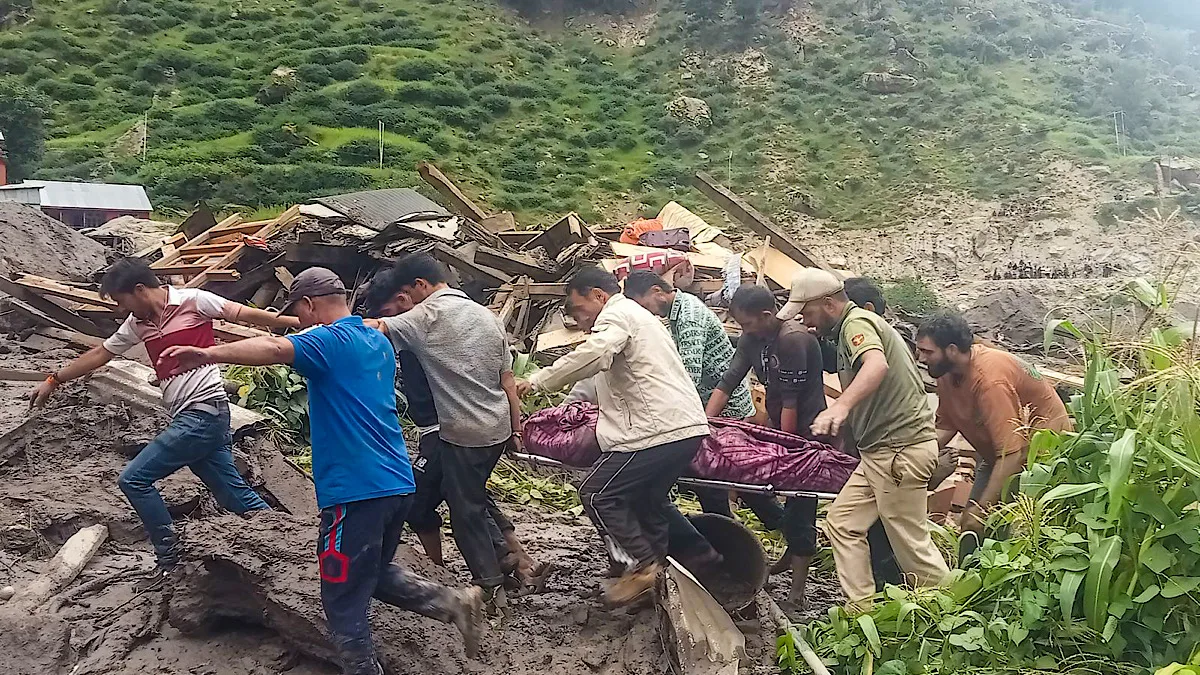
On August 14, 2025, between 11:30 AM and 01:00 PM, a cloudburst-induced flash flood and debris flow struck Chisoti in Kishtwar (J&K), turning a roadhead for the revered Machail Mata temple into a scene of unimaginable tragedy. With 42 persons confirmed dead and a large number still missing, this disaster serves as a chilling reminder that the old ways of managing pilgrimage and tourism in this fragile region are dangerously inadequate.
The time for reactive measures and mere luck is over.
With a rapidly changing climate intensifying extreme rainfall events and accelerating the formation and expansion of high-altitude glacial lakes, the Himalayan region stands at a critical crossroads.
The safety of its millions of visitors and residents depends on a fundamental shift in our approach and here we discuss an outline of a comprehensive, integrated blueprint for a future where these cherished destinations are managed not by chance, but by conscious, planned, and coordinated action.
The New Himalayan Reality: Cloudbursts, Debris Flows, and Geomorphic Time Bombs
For generations, mountain communities have coexisted with the Himalayas‘ predictable rhythms. But today, the rhythm is broken.
Experts and environmentalists widely attribute the increasing frequency and devastating potential of extreme weather events to rising global temperatures, which enhance the atmosphere’s water-holding capacity. This results in sudden, intense downpours that trigger flash floods and debris flows of a magnitude rarely seen before.
The Chisoti event is a perfect case study. The roadhead, a bustling hub for pilgrims, was located precariously close to the stream. Eyewitnesses recall a terrifying loud sound—a prelude to the disaster—followed by a sudden gush of debris-laden water that, in a split-second, overwhelmed the settlement.
This was not a gradual flood; it was a high-velocity surge that left no time for escape, tragically claiming lives and obliterating infrastructure. The initial reports of 42 confirmed deaths, with many more missing, underscore the lethal combination of geological vulnerability and human concentration.
The Looming Glacial Lake Threat: A Growing Danger
Beyond cloudbursts, another, more silent, threat is escalating in the Higher Himalayas: the sudden failure of glacial lakes. As global temperatures rise, glaciers are receding at an alarming rate, leading to the formation of new glacial lakes or the rapid expansion of existing ones.
These lakes, often held back by unstable moraine or ice dams, are essentially geomorphic time bombs. When a dam fails—due to an avalanche (as was believed to be the trigger for the 2021 Dhauliganga flood), a landslide, or even the sheer pressure of water—it can release a catastrophic volume of water in a phenomenon known as a Glacial Lake Outburst Flood (GLOF).
The potential for a GLOF to trigger a devastating flash flood is immense, and its risk has been tragically underestimated in many pilgrimage and tourist circuits. The absence of specific provisions for identifying, monitoring, and providing early warnings for these glacial lakes leaves a significant gap in our disaster preparedness, especially in the high-altitude zones where trekking routes often lie downstream.
The Dilemma of the Devotee and the Administrative Inertia
The immense casualties in these disasters often stem from a critical disconnect between the administration, the scientific community, and the visitors themselves.
The Visitor’s Mindset
Millions visit the Himalayas with pre-planned and often rigid travel schedules.
Having traveled long distances, they are naturally reluctant to turn back or reschedule, even in the face of adverse weather warnings.
They are also often unaware of the local geographical adversities and the sudden discharge potential of seasonal streams.
All these factors induce visitors to overlook warnings or take them casually, leading to a high casualty rate.
The Administrative Lag
While the revered places, the number of visitors, and the peak seasons are no secret to the administration, the response often falls short.
Preparation is typically restricted to general logistics, sanitation, and health-related issues, while the core vulnerabilities of crowd control and geological hazards are neglected.
The Chisoti event, for which IMD had issued a clear Red Alert of extremely heavy rains, is a powerful example of a failure to translate a scientific warning into an effective, life-saving administrative action.
A Blueprint for Safety: From Rhetoric to Action
To build a genuinely safe and secure Himalayan experience, we need a decisive shift in how we manage our major destinations. The following measures must be embraced with a sense of urgency and political will:
Integrated Risk Assessment and Monitoring
Our disaster management strategy must be founded on robust science. This requires a comprehensive approach to mapping and monitoring:
Flash Flood and GLOF Vulnerability Mapping
Detailed vulnerability and risk assessments of all major tourist and pilgrimage destinations must be conducted using state-of-the-art GIS and remote sensing techniques, backed by detailed geological and hydrological studies.
The focus must be on mapping vulnerable areas around identified destinations and trekking routes.
Glacial Lake Monitoring
Given the escalating threat, all high-altitude glacial lakes must be identified, mapped, and prioritized for real-time monitoring.
This involves using satellite imagery, ground sensors, and unmanned aerial vehicles to detect changes in lake volume, dam stability, and any signs of potential outburst.
Hydro-Meteorological Network
A strengthened network of automatic weather stations with real-time data transmission capability must be installed, particularly in the upper catchments of vulnerable streams.
This will provide the data necessary for generating accurate and timely rainfall-threshold-based warnings.
Proactive Crowd and Infrastructure Management
We must abandon the reactive model of crowd management and adopt proactive, coordinated strategies:
Regulated Access
Administrative and security apparatus – Police and Home Guard, must be deployed at all roadheads to regulate the number of people accessing trekking routes.
During adverse weather warnings, all movement must be stopped and low-lying areas evacuated.
Safe Infrastructure
A detailed vulnerability assessment of roadheads and halting stations is paramount.
All structures, new and old, must be evaluated and legally mandated to be a safe distance from streams and rivers.
The government must have the political courage to enforce floodplain zoning regulations and, where necessary, relocate existing infrastructure from high-risk zones.
Medical and Communication Infrastructure
Medical posts with first-aid, triage, and evacuation facilities must be a standard feature at all vulnerable points.
Public address systems must be put in place to communicate warnings, weather updates, and the status of movement resumption.
Communicating Risk and Empowering Communities
Warnings and safety measures are only effective if they are understood and acted upon.
Clear, Actionable Warnings
Warnings must be widely circulated through multiple channels – public address systems, mobile alerts, social media, and be simple, specific, and actionable.
Risk Communication
Information about risks, including GLOFs, must be made accessible to the public, particularly those planning a trip.
The government must go beyond logistics and actively educate visitors about the inherent geological adversities and the importance of respecting warnings and flexible travel plans.
Community Engagement
Local communities, who possess invaluable traditional knowledge, must be at the core of this strategy.
They should be trained in search and rescue and integrated into the early warning and communication networks.
Conclusion: A Choice for Survival
The tragedies at Dharali and Chisoti are not just news headlines; they are profound lessons etched in sorrow.
These demonstrate a glaring need to re-evaluate our relationship with the Himalayas.
The changing climate is a reality we must live with, but the resulting disasters are not an inevitability.
By investing in scientific monitoring, enforcing strict regulations on land use, managing visitor flow with a focus on safety over numbers, and empowering both visitors and local communities with knowledge, we can build a resilient system.
This blueprint offers a path for planners and policymakers to shed inertia, pool resources, and make the difficult decisions necessary to ensure the safety and security of all who seek solace and adventure in the mountains.
This is not a choice between economy and ecology; it is a choice for the sustainable survival of the Himalayas and its people.
Key DRR Lessons
Anticipate Beyond the Obvious
The flash floods are not just caused by cloudbursts. DRR planning must account for complex and catastrophic triggers like rockslide-induced floods and the escalating threat of Glacial Lake Outburst Floods (GLOFs).
Integrate Science and Action
There is pressing need to bridge the gap between scientific warnings and administrative action.
This involves using tools like GIS for vulnerability mapping, establishing dedicated glacial lake monitoring systems, and creating a mechanism to translate scientific alerts into immediate, on-the-ground preparedness measures.
Enforce Smart Land-Use
The tragedies at Chisoti and Dharali underscore the fatal consequences of building on vulnerable land, particularly in proximity to streams and on alluvial fans.
A core lesson is the urgent need for strict floodplain zoning regulations and the political will to enforce these, preventing the concentration of human activity in high-risk zones.
Prioritise People Over Numbers
The success of pilgrimage and tourism cannot be measured solely by visitor count. A sustainable model requires regulating visitor flow, especially during peak seasons and adverse weather, to prevent overcrowding and reduce the overall risk.
Value Traditional Wisdom
Modern DRR strategies must integrate the invaluable traditional knowledge of Himalayan communities. This time-tested wisdom on where to build and how to coexist with the landscape is a crucial, often-forgotten, asset for building resilience.
आज हमने क्या सीखा
- साधारण कारणों से कुछ आगे: बादल फटना ही त्वरित बाढ़ का एकमात्र कारण नहीं हैं। अतः आपदा जोखिम प्रबन्धन सम्बन्धित रणनीतियों को जटिल व एक के बाद एक आरम्भ होने वाली धटनाओ – जैसे कि भू- स्खलन / हिम-स्खलन प्रेरित बाढ़ तथा भू-स्खलन निर्मित या ग्लेशियर झीलों के रिसाव से उत्पन्न बाढ़ को भी संज्ञान में लेना चाहिये।
- वैज्ञानिक चेतावनी व प्रशासनिक कार्यवाही में समन्वय: वैज्ञानिक व तकनीकी संस्थाओ द्वारा दी जाने वाली चेतावनी के आधार पर त्वरित व प्रभावी प्रशासनिक कार्यवाही सुश्चित करने के लिये धरातल पर वांछित व्यवस्थायें की जानी आवश्यक हैं। इसके लिये भौगोलिक सूचना प्रणाली व सुदूर संवेदन तकनीक के साथ ही अन्य आधुनिक वैज्ञानिक तकनीकों का उपयोग कर विशेष रूप से ग्लेशियर झीलों की निगरानी के साथ ही वैज्ञानिक चेतावनियों को धरातल पर वांछित कार्यवाही में रूपान्तरित करने के किये आवश्यक तैयारी व क्षमता विकास किया जाना आवश्यक हैं।
- चतुर व प्रभावी भू-उपयोग नियोजन: धराली हो या फिर चिशौती, उच्च जोखिम वाले क्षेत्र, विशेष रूप से नदी – नालो के समीप, मानवीय हस्तक्षेप के कारण क्षति के परिमाण में वृद्धि हुयी हैं। अतः उच्च जोखिम वाले क्षेत्रों का निर्धारण कर, इस जानकारी का उपयोग समुदाय को जागरूक करने, भू – उपयोग नीति बनाने, जोखिम कम करने व विकास कार्यो के नियोजन तथा उच्च जोखिम वाले क्षेत्रों में मानवीय हस्तक्षेप को कम करने के लिये किया जाना चाहिये।
- संख्या की अपेक्षा मानवीय पक्षों को प्राथमिकता: पर्यटन हो या फिर तीर्थाटन – उसकी सफलता का मापदंड मात्र आने वाले व्यक्तियों की संख्या नहीं हो सकती। भीड़ नियंत्रण व जोखिम न्यूनीकरण के दृष्टिगत विशेष रूप से ज्यादा लोगो की सम्भावना वाले समय तथा विषम मौसम की चेतावनी की स्थिति में भीड़ प्रबन्धन के समुचित उपाय किये जाने चाहिये।
- समुदाय का क्षमता विकास: किसी भी आपदा या आपातकालीन स्थिति में स्थानीय समुदाय ही प्रथम प्रातिवादक होता हैं। अतः उसके क्षमता विकास पर अपेक्षित ध्यान दिया जाना चाहिये। समुदाय के सदस्यों में आपदा के चिन्हों का पूर्वाभास करने, जोखिम मानचित्रो व चेतावनियों को स्थानीय परिप्रेक्ष में समझने व आपातकालीन निर्णय-निर्धारण करने की क्षमता होनी चाहिये। इससे समुदाय मात्र आपदा प्रभावित होने की अपेक्षा, अपनी व अपने लोगो की सुरक्षा का सूत्रधार बन सकता हैं।
- परम्परागत ज्ञान का सम्मान: आपदा जोखिम न्यूनीकरण हेतु हिमालय में पीढ़ियों से रह रहे समुदायों का परम्परागत ज्ञान एक अमूल्य निधि हैं। वर्तमान में किये जाने वाले नियोजन व नीति निर्धारण में लोगो के परम्परागत ज्ञान को समावेशित किया जाना चाहिये। इससे हमें सहज ही सुदृढ़, समाज को स्वीकार्य व मितव्ययी समाधान मिल सकते हैं।
हमें हमेशा की तरह आपके सुझावों, प्रतिक्रियाओं व कटाक्षो का बेसब्री से इंतजार रहता हैं और सच मानिये इसी के आधार पर हम अपने आप में, अपनी सोच व रचनात्मकता में सुधार करने को प्रेरित होते हैं।
सो अच्छा – बुरा जैसा आपको महसूस हुवा हो, कमेंट जरुर करते रहें।
[…] disaster has gripped the nation. While the mountainous states of Uttarakhand, Himachal Pradesh, and Jammu and Kashmir grappled with the fury of landslides and flash floods, Punjab — the nation’s breadbasket — […]