 The images are tragically familiar, etched into our collective memory – Kedarnath engulfed in 2013, the ferocious Teesta river sweeping away parts of Sikkim in 2023, destructive surges in Himachal Pradesh, and most recently, the heartbreaking devastation at Dharali in Uttarkashi on August 5, 2025.
A sudden, ferocious flash flood, reportedly triggered by the breach of a temporary lake or cloudburst in the upper reaches of the Kheerganga, swept through the area, a grim reminder that in the Himalayas, nature‘s power is both beautiful and terrifyingly unpredictable.
But was it truly unpredictable?
The heartbreaking images of Dharali, much like those of the Dhauliganga tragedy in February 2021, prompt a critical question: Can we move beyond reacting to these catastrophes and begin to anticipate these?
We thus explore a holistic approach to do just that — a method that uses the landscape‘s own flood signatures to assess where the next disaster might strike, while also emphasising the forgotten wisdom of our ancestors and the urgent need for a change in our developmental ethos.
Anatomy of a Catastrophe: Beyond the Cloudburst
These aren’t your typical floods where water rises gradually.
Flash floods are sudden, violent surges of water, often transforming a peaceful stream into a raging torrent in mere minutes. Their destructive power lies in their speed and sheer force, carrying a terrifying mix of boulders, trees, and debris.
While intense downpours known as cloudbursts are a common trigger, these are far from the only one.
Recent disasters have revealed more complex and often more violent triggers:
Rockslide / Avalanche-Induced Flash Floods
The Dhauliganga flood of February 2021, which many people believe was initiated by an avalanche, was, in fact, a massive rock and ice avalanche from a hanging glacier that detached high on a ridge.
This event, which some may refer to as a rockslide or avalanche, sent a mix of rock, ice, and debris hurtling down the valley.
The immense force and friction from this descent is believed to have melted the ice and picked up huge volumes of unconsolidated glacial material, creating a devastating surge that overwhelmed everything in its path including two hydropower projects at Rini and Tapoban.
Breach of Landslide-Dammed Lakes
A landslide can block a river, creating a temporary lake. When this natural dam fails, it releases a devastating wall of water downstream causing massive destruction.
Uttarakhand has a history of such events and these caused massive devastation in Alaknanda valley in 1894 and 1970.
Glacial Lake Outburst Floods (GLOFs)
The sudden release of water from a glacial lake, often caused by the collapse of an ice or moraine dam. These triggers unleash walls of water that obliterate homes, roads, and bridges.
It was the collapse of moraine dammed Chorabari lake in June 2013 that enhanced the devastating potential of the Mandakini floods and caused massive loss of life at Kedarnath, Rambara and Gaurikund.
Teesta flood of October 2023 was also one such incidence, caused by the breach of South Lhonak lake in Sikkim Himalaya.
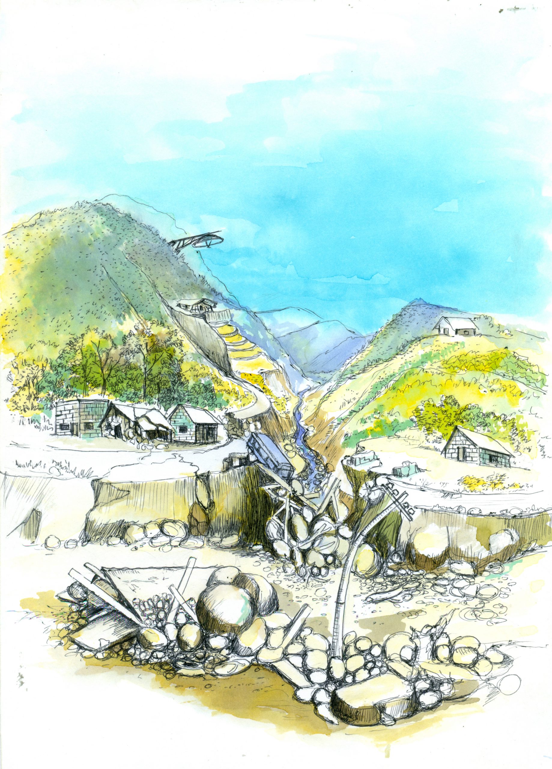
Reading the Landscape‘s Flood Signature: Why Dharali Was Vulnerable
To mitigate such risk, one must learn to read the signs that the landscape itself provides.
It needs to be appreciated that the Himalayan landscape holds distinct signatures based on which flash flood potential can be assessed.
Not all valleys are created equal; certain geographical features act as a perfect recipe for catastrophe.
An analysis of the Dharali devastation, and other similar events, reveal a consistent pattern in these high-risk areas.
The Giant Funnel – Catchment Area
Every river valley is a giant funnel, collecting rainwater and runoff.
A larger catchment area collects more water during a downpour, dramatically increasing the potential volume of a flood.
A seemingly small stream can have a massive funnel above it, a fact often overlooked by those living in the valley below.
The Steep Slide – Relative Relief
Relative relief, or the difference in elevation between the highest ridges and the valley floor, dictates the speed and power of the water.
High-relief areas mean water accelerates rapidly downhill, magnifying its destructive power like water jetting out of a nozzle.
The Dharali flood, for instance, gained its catastrophic force from the high-relief, steep-sided catchment area of the Kheerganga.
The Clogged Drainpipe – Misfit Streams
Stream channels in geologically active areas like the Himalayas are often disproportionately small compared to the size of their catchment area — a phenomenon known as a misfit stream.
When intense rainfall hits a large catchment with a narrow, choked channel, it’s like trying to drain a bathtub through a drinking straw; the channel quickly overflows, leading to a sudden and violent flash flood.
The Bare Slope vs. The Green Sponge – Vegetation
Dense forests act as a giant sponge, absorbing rainfall, slowing down surface runoff, and stabilising the soil.
Conversely, slopes with poor vegetation cover allow water to race off immediately, leading to faster, larger floods often carrying more sediment and debris.
Deforestation and land degradation can dramatically increase flash flood risk.
Living on the Edge – Settlement Proximity
Ultimately, the risk to humans escalates dramatically when villages, towns, or infrastructure are located close to stream channels identified as having high flood potential.
The tragedy at Dharali was compounded by settlements built in the immediate proximity of the vulnerable stream, often on the floodplain and alluvial fan itself.
Traditional Knowledge: A Forgotten Fortress
Before the advent of modern science and technology, Himalayan communities relied on a different kind of expertise: generations of traditional knowledge. This wisdom, deeply rooted in a profound and practical understanding of the local environment, was their first line of defence against disasters.
Our ancestors understood the inherent vulnerability of the landscape.
They knew where not to build, choosing higher, more stable ground for their habitations, even if it meant sacrificing comfort for safety.
They built their homes with locally available, flexible materials that could withstand ground shaking, and their agricultural practices, like intricate terrace farming, were designed to manage water flow and prevent erosion.
They read the subtle signs of nature—changes in discharge and turbidity of springs and streams, weather patterns, and vegetation growth pattern, the behaviour of animals, birds and insects and unusual ground movement — as early warnings of impending danger.
Today, this invaluable, time-tested knowledge is largely ignored.
In our pursuit of modern convenience and development, we have abandoned these traditional dicta, often building new settlements and infrastructure in the very floodplains and unstable slopes that our ancestors wisely avoided.
The Dangers of Unchecked Development: Lessons Unlearned
The Dharali tragedy, much like the Dhauliganga event, serves as a grim case study of what happens when we ignore both modern science and traditional knowledge.
Experts suggest the devastating impact was significantly worsened by unchecked construction and unnecessary anthropogenic activities in the fragile Bhagirathi Eco-Sensitive Zone.
In our pursuit of economic gain, we have pushed the Himalayan ecosystem far beyond its carrying capacity.
Unsustainable Tourism and Pilgrimage
The massive influx of tourists and pilgrims, while economically profitable, puts an immense strain on the fragile environment.
The constant flow of vehicles, helicopters, and large-scale, often unregulated, construction to accommodate them has led to significant deforestation, slope modification, debris generation, increased carbon and black carbon emissions, and the encroachment on natural floodplains.
The very essence of pilgrimage—a spiritual journey—has been replaced by a consumerist model that is actively degrading the environment it seeks to honor.
Ignoring Traditional Land-Use
The structures destroyed in Dharali were built directly on the floodplain and alluvial fan, a violation of both common-sense and traditional ecological guidelines.
The pressure to build hotels, guesthouses, and homestays to cater to the tourist influx has led to the construction of permanent structures in highly vulnerable zones.
Disrupting Natural Systems
Road widening projects, unscientific debris disposal, and other developmental activities disrupt natural drainage patterns and destabilise slopes, making them more susceptible to flash floods and landslides.
The push to build infrastructure without a deep understanding of the local geology and hydrology is a recipe for disaster.
From Maps to Mitigation: A Path Forward
The path to a landslide-safe and flash-flood-resilient Uttarakhand requires a radical and immediate shift from reactive to proactive strategies.
It’s not enough to simply map the danger; we must act on that knowledge with a sense of urgency.
Integrated Hazard Mapping
The GIS and remote sensing based methodology backed by sound ground truthing, can identify high-risk zones based on the landscape‘s flood signatures and correlating these with a number of other parameters – from geology to rainfall through slope amount and aspect, is an invaluable tool.
It allows authorities to pinpoint exactly which areas need immediate attention, allowing for a targeted and effective response.
Proactive Land-Use Planning
These maps must be used as the foundation for strict land-use policies.
We must legally prohibit any further construction in floodplains and other high-risk zones.
This is a non-negotiable step to prevent future Dharali-like tragedies.
The Chief Minister of Uttarakhand, Pushkar Singh Dhami, has proactively announced this which is a welcome measure, but then the administrative follow up to put in place policy and rules together with implementation, monitoring and compliance mechanisms have to come by.
Restricting Anthropogenic Activities
We must set clear limits on tourism and pilgrimage in these fragile eco-sensitive zones.
This could involve daily visitor quotas, restricting vehicle access, and implementing a strict zero-tolerance policy on unregulated construction and debris disposal.
Honouring Traditional Knowledge
We need to integrate traditional knowledge into our modern disaster management strategies.
By combining scientific mapping with the on-ground wisdom of local communities, we can create more robust and socially acceptable solutions.
Focused Monitoring and Early Warning
The GIS and remote sensing analysis can pinpoint the high-risk watersheds that most urgently need investment in meteorological stations for real-time rainfall data.
This data, combined with community knowledge, can form the basis of a targeted, effective early warning system.
Conclusion: A Choice for Survival and Sustainability
The Himalayan landscape holds immense power, and flash floods are one of its most dangerous expressions.
The devastating events at Dharali and elsewhere are not simply random acts of nature; these are a tragic confluence of natural vulnerability and human activity.
While we cannot tame the storms or halt every landslide, we can and must choose to live with the mountains, not against them.
By embracing an integrated approach that blends scientific mapping with the invaluable traditional knowledge of our communities, and by having the courage to restrict unnecessary anthropogenic activities, we can shift from a cycle of disaster and reaction to a future of resilience and sustainable coexistence.
The time for this paradigm shift is not in the wake of the next tragedy, but now.
It is a choice for survival, for sustainability, and for a future where the beauty of the Himalayas is cherished and respected, not feared.
आज हमने क्या सीखा
- साधारण कारणों से कुछ आगे: बादल फटना ही त्वरित बाढ़ का एकमात्र कारण नहीं हैं। अतः आपदा जोखिम प्रबन्धन सम्बन्धित रणनीतियों को जटिल व एक के बाद एक आरम्भ होने वाली धटनाओ – जैसे कि 2021 की भू- स्खलन / हिम-स्खलन प्रेरित धौलीगंगा बाढ़ – एवं भू-स्खलन निर्मित या ग्लेशियर झीलों के रिसाव से उत्पन्न बाढ़ – को संज्ञान में लेना चाहिये।
- तकनीक व भू-भाग की विशिष्टता का संगम: क्षेत्र में किये गये सर्वेक्षणों से प्राप्त जानकारियों को भौगोलिक सूचना प्रणाली सहित अन्य आधुनिक वैज्ञानिक तकनीकों के उपयोग से विश्लेषित कर उच्च जोखिम वाले क्षेत्रों का निर्धारण किया जाना चाहिये और इस जानकारी का उपयोग समुदाय को जागरूक करने, भू – उपयोग नीति बनाने, जोखिम कम करने व विकास कार्यो के नियोजन के लिये भी किया जाना चाहिये।
- परम्परागत ज्ञान का सम्मान: आपदा जोखिम न्यूनीकरण हेतु हिमालय में पीढ़ियों से रह रहे समुदायों का परम्परागत ज्ञान एक अमूल्य निधि हैं। वर्तमान में किये जाने वाले नियोजन व नीति निर्धारण में लोगो के परम्परागत ज्ञान को समावेशित किया जाना चाहिये। इससे हमें सहज ही सुदृढ़, समाज को स्वीकार्य व मितव्ययी समाधान मिल सकते हैं।
- भू-उपयोग नीति का प्रख्यापन व अनुपालन: उच्च जोखिम वाले क्षेत्रों में प्रभावी भू-उपयोग नीति के माध्यम से मानवीय हस्तक्षेप को पूर्णतः प्रतिबन्धित करने के लिये निश्चित ही दृढ़ राजनैतिक इच्छाशक्ति की आवश्यकता हैं। उत्तराखण्ड के मुख्य मंत्री ने इस दिशा में पहल कर एक सकारात्मक सन्देश दिया हैं, परन्तु इसे आपदा उपरान्त की अवधि में दिया गया भावुक बयान साबित नहीं होना चाहिये, और इसके त्वरित व प्रभावी क्रियान्वयन के लिये तत्काल आवश्यक प्रशासनिक कार्यवाही की जानी चाहिये।
- प्रतिक्रियात्मक से अग्रसक्रिय: हमारा लक्ष्य आपदा उपरान्त त्वरित व प्रभावी प्रतिवादन से आगे बढ़, तकनीक व परम्परागत ज्ञान के उपयोग से आपदाओं का पूर्वानुमान कर आपदा रोकथाम व न्यूनीकरण सम्बन्धित उपायों का प्रभावी नियोजन तथा क्रियान्वयन पर केन्द्रित होना चाहिये।
- मानवजनित दबाव का न्यूनीकरण: अनियोजित, अवैज्ञानिक व अनियन्त्रिक विकास, अवहनीय व गैर-जिम्मेदार पर्यटन तथा बेतरतीब मलबा निस्तारण क्षेत्र की आपदा घातकता को बढ़ाने के लिये उत्तरदायी हैं। अतः हमें क्षेत्र की धारण क्षमता का निर्धारण करते हुवे वैज्ञानिक व नियोजित अपशिष्ट व मलबा निस्तारण, पारिस्थिति अनुकूल सड़क निर्माण व वहनीय पर्यटन हेतु कारगर रणनीतियों के विकास व इनके क्रियान्वयन पर ध्यान केन्द्रित करना चाहिये।
- समुदाय का क्षमता विकास: किसी भी आपदा या आपातकालीन स्थिति में स्थानीय समुदाय ही प्रथम प्रातिवादक होता हैं। अतः उसके क्षमता विकास पर अपेक्षित ध्यान दिया जाना चाहिये। समुदाय के सदस्यों में आपदा के चिन्हों का पूर्वाभास करने, जोखिम मानचित्रो व चेतावनियों को स्थानीय परिप्रेक्ष में समझने व आपातकालीन निर्णय-निर्धारण करने की क्षमता होनी चाहिये। इससे समुदाय मात्र आपदा प्रभावित होने की अपेक्षा, अपनी व अपने समुदाय की सुरक्षा का सूत्रधार बन सकता हैं।
हमें हमेशा की तरह आपके सुझावों, प्रतिक्रियाओं व कटाक्षो का बेसब्री से इंतजार रहता हैं और सच मानिये इसी के आधार पर हम अपने आप में, अपनी सोच व रचनात्मकता में सुधार करने को प्रेरित होते हैं।
सो अच्छा – बुरा जैसा आपको महसूस हुवा हो, कमेंट जरुर करते रहें।
Seen and understand,
A reliable conversation covering most important aspects of such disasters, the risk and vulnerability of such hazards must be considered not only planners,geologist and engineers but also by community and other stakeholders , particularly along such fragile mountain terrain.
Very deeply explained, tipical terms generally we used in disaster.